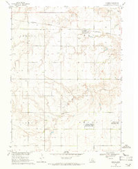
1969 Map of Norman
USGS Topo · Published 1971About this map
Norman serves as the central hub of this late-1960s landscape, positioned along the Burlington Northern railroad line in Kearney County. The surrounding townships of Lincoln, Cosmo, and Grant reveal a highly organized agricultural grid typical of the Missouri River Basin development era. This survey is particularly useful for genealogical research, as it identifies localized landmarks such as Osco Ch and two distinct burial grounds, Norman Cem and May Cem, which anchor the rural community. Environmental preservation is noted through the presence of the Jensen Lagoon National Wildlife Management Area and the Youngson Lagoon National Wildlife Management Area. These protected wetlands contrast with the surrounding dryland farming, while drainage is defined by the winding paths of Sand Creek and the South Branch Sand Creek.
Find a feature on this map
12 named features on this map. Tap any name to fly to it.
Don’t see what you’re looking for? This feature index may not catch every label — zoom into the map to look around manually.
Map Details
Editions of this 1969 Norman Map
This is the sole edition of this map. No revisions or reprints were ever made.
Other maps of this area

1894 · Kenesaw
USGS Topo · 1:62,500

1894 · Minden
USGS Topo · 1:62,500

1896 · Wood River
USGS Topo · 1:125,000

1897 · Red Cloud
USGS Topo · 1:125,000

1955 · Grand Island
USGS Topo · 1:250,000

1957 · Grand Island
USGS Topo · 1:250,000

1958 · Grand Island
USGS Topo · 1:250,000

1969 · Upland
USGS Topo · 1:24,000

1969 · Upland SE
USGS Topo · 1:24,000
1969 · Holstein
USGS Topo · 1:24,000