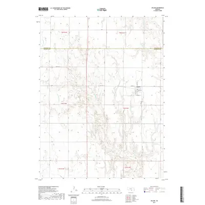
2017 Map of Upland
USGS Topo · Published 2017About this map
Upland serves as the central hub of this Nebraska landscape, where the local Po and a grid of residential streets like Belfield St and Midland St anchor the community. The surrounding terrain is defined by a dense network of sectional roads and the winding paths of the W Br Thompson Cr and the Little Blue River. To the north and east, agricultural water management is evident in the presence of Olson Reservoir and Bertrand Reservoir, which reflect the region's reliance on managed water resources for its farming economy. The map also documents the historical resting place at Upland Cem, located just south of the main town site. Positioned along the border of Kearney Co and Franklin Co, this survey illustrates the intersection of small-town infrastructure and the vast rural expanses of the Great Plains.
Find a feature on this map
25 named features on this map. Tap any name to fly to it.
Don’t see what you’re looking for? This feature index may not catch every label — zoom into the map to look around manually.
Map Details
Editions of this 2017 Upland Map
This is the sole edition of this map. No revisions or reprints were ever made.
Other maps of this area
1896 · Holdrege
USGS Topo · 1:125,000
1897 · Red Cloud
USGS Topo · 1:125,000
1955 · Grand Island
USGS Topo · 1:250,000
1957 · Grand Island
USGS Topo · 1:250,000
1958 · Grand Island
USGS Topo · 1:250,000
1969 · Upland
USGS Topo · 1:24,000
1969 · Upland SE
USGS Topo · 1:24,000
1969 · Norman
USGS Topo · 1:24,000
1969 · Minden South
USGS Topo · 1:24,000
1970 · Axtell East
USGS Topo · 1:24,000