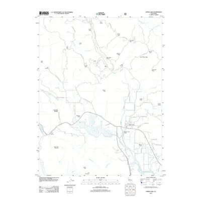
2012 Map of Upper Lake
USGS Topo · Published 2012About this map
Upper Lake sits at the nexus of several creek systems in this 2012 survey, where Scotts Cr, Middle Cr, and Clover Cr converge toward the wetlands of Tule Lake. The settlement pattern follows the productive basins of Bachelor Valley and Middle Creek Valley, connected by historical routes like Bachelor Valley Rd. To the west, the community of Saratoga Springs and the nearby Witter Springs reflect the region's long-standing connection to local water sources. The terrain is defined by significant ridges and peaks including Sleeper Peak, White Rock Mountain, and Poe Mountain, while the name Bloody Island in the southeast serves as a reminder of the area's complex historical narrative. Northward, the landscape becomes increasingly remote, marked by high points such as Youngs Peak and the isolated Hunter Ranch along White Rock Canyon Rd.
Find a feature on this map
75 named features on this map. Tap any name to fly to it.
Don’t see what you’re looking for? This feature index may not catch every label — zoom into the map to look around manually.
Map Details
Editions of this 2012 Upper Lake Map
This is the sole edition of this map. No revisions or reprints were ever made.
Other maps of this area

1920 · Ukiah
USGS Topo · 1:62,500

1922 · Hullville
USGS Topo · 1:62,500

1938 · Lakeport
USGS Topo · 1:62,500

1943 · Pomo
USGS Topo · 1:62,500

1944 · Ukiah
USGS Topo · 1:62,500

1951 · Lake Pillsbury
USGS Topo · 1:62,500

1951 · Lakeport
USGS Topo · 1:62,500

1957 · Ukiah
USGS Topo · 1:250,000
1958 · Purdys Gardens
USGS Topo · 1:24,000

1958 · Cow Mountain
USGS Topo · 1:24,000