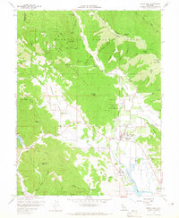
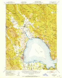
1958 Map of Upper Lake
USGS Topo · Published 1965About this map
Upper Lake (Pomo) Rancheria and Robinson Rancheria are central landmarks in this valley landscape, where agriculture and early settlements meet the foothills of the Mendocino National Forest. The map documents a complex water system dominated by Tule Lake and Rodman Slough, with areas noted as subject to occasional inundation. Significant historical sites are clearly marked, including the Bloody Island Massacre Historical Marker on Bloody Island, which provides crucial context for the regional history of the 19th century. Along the western edge, the community of Witter Springs and the resort at Saratoga Springs highlight the importance of the area's natural mineral waters. High-elevation points like Hunter Point Lookout on Middle Mountain overlook a network of jeep trails and firebreaks, reflecting the forest management and fire suppression efforts of the late 1950s.
Find a feature on this map
53 named features on this map. Tap any name to fly to it.
Don’t see what you’re looking for? This feature index may not catch every label — zoom into the map to look around manually.
Map Details
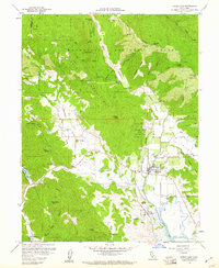
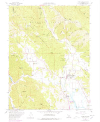
Editions of this 1958 Upper Lake Map
3 editions found
Other maps of this area

1920 · Ukiah
USGS Topo · 1:62,500

1922 · Hullville
USGS Topo · 1:62,500

1938 · Lakeport
USGS Topo · 1:62,500

1943 · Pomo
USGS Topo · 1:62,500

1944 · Ukiah
USGS Topo · 1:62,500
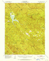
1951 · Lake Pillsbury
USGS Topo · 1:62,500
1951 · Lakeport
USGS Topo · 1:62,500

1957 · Ukiah
USGS Topo · 1:250,000
1958 · Purdys Gardens
USGS Topo · 1:24,000
1958 · Cow Mountain
USGS Topo · 1:24,000