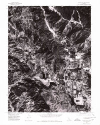
1977 Map of Upper Lake
USGS Topo · Published 1980About this map
Upper Lake serves as the focal point for this late-1970s orthophotoquad, where the transition from flat valley agriculture to steep mountainous terrain is captured with photographic precision. The fertile corridor of Bachelor Valley is clearly visible, showing a patchwork of cultivated fields and orchard layouts that have long defined the local economy. Water management is a central theme in this landscape, dominated by the drainage of Middle Creek as it winds toward the larger basin. To the southwest, the rise of White Rock Mtn provides a stark topographic contrast to the settlement area, illustrating the natural boundaries that shaped the development of northern Lake County. This aerial perspective, prepared by the Geological Survey, offers researchers a raw look at land use and vegetation patterns before modern expansion altered these rural outskirts.
Find a feature on this map
4 named features on this map. Tap any name to fly to it.
Don’t see what you’re looking for? This feature index may not catch every label — zoom into the map to look around manually.
Map Details
Editions of this 1977 Upper Lake Map
This is the sole edition of this map. No revisions or reprints were ever made.
Other maps of this area

1920 · Ukiah
USGS Topo · 1:62,500

1922 · Hullville
USGS Topo · 1:62,500

1938 · Lakeport
USGS Topo · 1:62,500

1943 · Pomo
USGS Topo · 1:62,500

1944 · Ukiah
USGS Topo · 1:62,500

1951 · Lake Pillsbury
USGS Topo · 1:62,500

1951 · Lakeport
USGS Topo · 1:62,500

1957 · Ukiah
USGS Topo · 1:250,000
1958 · Purdys Gardens
USGS Topo · 1:24,000

1958 · Cow Mountain
USGS Topo · 1:24,000