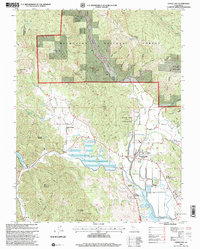
1996 Map of Upper Lake
USGS Topo · Published 2001About this map
Tule Lake and the surrounding basin of the Mendocino Mountains anchor this 1996 revision of Lake County. The landscape is defined by the drainage of Middle Creek and Clover Creek as they descend into Clover Valley, supporting a mix of tribal lands and small agricultural settlements. The map highlights the tribal heritage of the area, including the Upper Lake (Pomo) Rancheria and Robinson Rancheria, alongside the Bloody Island Massacre Historical Marker near Bloody Island.
Find a feature on this map
105 named features on this map. Tap any name to fly to it.
Don’t see what you’re looking for? This feature index may not catch every label — zoom into the map to look around manually.
Map Details
Editions of this 1996 Upper Lake Map
This is the sole edition of this map. No revisions or reprints were ever made.
Other maps of this area

1920 · Ukiah
USGS Topo · 1:62,500

1922 · Hullville
USGS Topo · 1:62,500

1938 · Lakeport
USGS Topo · 1:62,500

1943 · Pomo
USGS Topo · 1:62,500

1944 · Ukiah
USGS Topo · 1:62,500

1951 · Lake Pillsbury
USGS Topo · 1:62,500

1951 · Lakeport
USGS Topo · 1:62,500

1957 · Ukiah
USGS Topo · 1:250,000
1958 · Purdys Gardens
USGS Topo · 1:24,000

1958 · Cow Mountain
USGS Topo · 1:24,000