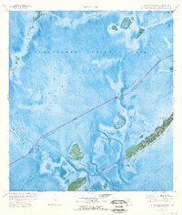
1971 Map of Upper Matecumbe Key
USGS Topo · Published 1973About this map
Islamorada serves as the primary hub of development on Upper Matecumbe Key, marking a significant point of human presence amidst the expansive waters of Florida Bay. The 1971 orthophotomap detail captures the intricate relationship between the Overseas Highway and the surrounding archipelago, including the Teatable Key Fill and the nearby Indian Key. This survey highlights the region's hydrography, showing the complex network of channels such as Steamboat Channel and Race Channel that navigate between shallow banks like the Lignumvitae Key Bank.
Find a feature on this map
45 named features on this map. Tap any name to fly to it.
Don’t see what you’re looking for? This feature index may not catch every label — zoom into the map to look around manually.
Map Details
Editions of this 1971 Upper Matecumbe Key Map
3 editions found
Other maps of this area

1956 · Miami
USGS Topo · 1:250,000

1958 · Miami
USGS Topo · 1:250,000

1971 · Upper Matecumbe Key
USGS Topo · 1:24,000

1971 · Tavernier
USGS Topo · 1:24,000

1971 · Plantation Key
USGS Topo · 1:24,000

1971 · Long Key
USGS Topo · 1:24,000
1971 · Lower Matecumbe Key
USGS Topo · 1:24,000

1972 · Pelican Keys
USGS Topo · 1:24,000

1972 · Buchanan Keys
USGS Topo · 1:24,000

1972 · Calusa Keys
USGS Topo · 1:24,000