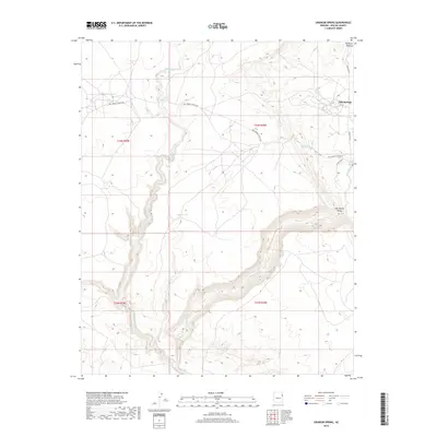
2018 Map of Uranium Spring
USGS Topo · Published 2018About this map
The high elevation terrain of the Defiance Plateau defines this landscape in Apache County, where rugged drainage systems like the W Fork Black Cr and Black Cr carve through the sandstone. The small settlement of Oak Springs sits at the edge of Oak Spring Valley, served by the intersection of Indian Rte 12 and Co Rd C610. This modern survey illustrates the sparse but vital water infrastructure necessary for life in the high desert, including Uranium Spring and Campus Tank. The presence of Pine Springs School Rd suggests the historical importance of local education centers in connecting scattered ranching or tribal communities across the vast plateaus of the Navajo Nation boundary lands.
Find a feature on this map
52 named features on this map. Tap any name to fly to it.
Don’t see what you’re looking for? This feature index may not catch every label — zoom into the map to look around manually.
Map Details
Editions of this 2018 Uranium Spring Map
This is the sole edition of this map. No revisions or reprints were ever made.
Other maps of this area

1886 · Fort Defiance
USGS Topo · 1:250,000

1892 · Fort Defiance
USGS Topo · 1:250,000

1954 · Gallup
USGS Topo · 1:250,000

1958 · Gallup
USGS Topo · 1:250,000

1959 · Gallup
USGS Topo · 1:250,000

1962 · Gallup
USGS Topo · 1:250,000

1967 · Gallup
USGS Topo · 1:250,000

1971 · Burntwater Wash
USGS Topo · 1:24,000
1971 · Joe Woody Well
USGS Topo · 1:24,000
1971 · Hunters Point
USGS Topo · 1:24,000