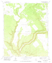
1971 Map of Uranium Spring
USGS Topo · Published 1975About this map
The Navajo Indian Reservation landscape is defined by the carved path of Black Creek and its southern tributary, the West Fork Black Creek. In this high-desert region of Apache County, water sources are the primary indicators of human activity and survival. Named features like Uranium Spring, Oak Spring, and Burnside Well mark critical points in an otherwise arid environment, while the presence of Corrals and a remote Jeep Trail suggest a reliance on ranching and seasonal movement of livestock. Small-scale exploration is evident near the creek through labeled Prospects, hinting at the mineral interests that likely gave the area's namesake spring its name. The layout of Campus Tank and various unnamed wells underscores the engineering required to sustain life and industry in the interior of the reservation during the early 1970s.
Find a feature on this map
14 named features on this map. Tap any name to fly to it.
Don’t see what you’re looking for? This feature index may not catch every label — zoom into the map to look around manually.
Map Details
Editions of this 1971 Uranium Spring Map
This is the sole edition of this map. No revisions or reprints were ever made.
Other maps of this area

1886 · Fort Defiance
USGS Topo · 1:250,000

1892 · Fort Defiance
USGS Topo · 1:250,000

1954 · Gallup
USGS Topo · 1:250,000

1958 · Gallup
USGS Topo · 1:250,000

1959 · Gallup
USGS Topo · 1:250,000

1962 · Gallup
USGS Topo · 1:250,000

1967 · Gallup
USGS Topo · 1:250,000

1971 · Burntwater Wash
USGS Topo · 1:24,000
1971 · Joe Woody Well
USGS Topo · 1:24,000
1971 · Hunters Point
USGS Topo · 1:24,000