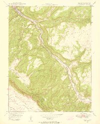
1948 Map of Uravan
USGS Topo · Published 1955About this map
Uravan sits at the confluence of the San Miguel River and Hieroglyphic Canyon, serving as a focal point for postwar industrial activity. Published in conjunction with the Atomic Energy Commission, this 1948 field survey documents the intensive mining landscape of Montrose County during the early Cold War uranium boom. The geography is defined by high plateaus like Spring Creek Mesa and Long Mesa, which are dissected by steep drainages and dotted with numerous small-scale operations. Researchers can identify many specific workings including the Club Mines, Rock Raven Mine, and the Forty-five Ninety Mine. Access to these remote sites was facilitated by a network of unimproved routes such as Long Park Road and various unnamed truck trails. The map also captures the settlement at Hoyt and the hydrologic importance of sources like Horsethief Spring in this arid canyon environment.
Find a feature on this map
43 named features on this map. Tap any name to fly to it.
Don’t see what you’re looking for? This feature index may not catch every label — zoom into the map to look around manually.
Map Details
Editions of this 1948 Uravan Map
2 editions found
Other maps of this area

1916 · Paradox Valley
USGS Topo · 1:125,000

1922 · Paradox Valley
USGS Topo · 1:125,000

1948 · Bull Canyon
USGS Topo · 1:24,000

1948 · Uravan
USGS Topo · 1:24,000

1948 · Naturita NW
USGS Topo · 1:24,000

1949 · Bull Canyon
USGS Topo · 1:24,000

1949 · Davis Mesa
USGS Topo · 1:24,000

1949 · Uravan
USGS Topo · 1:24,000

1949 · Naturita NW
USGS Topo · 1:24,000

1949 · Atkinson Creek
USGS Topo · 1:24,000