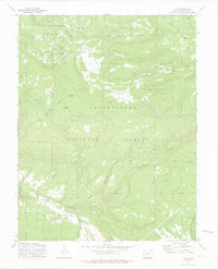
1973 Map of Ute
USGS Topo · Published 1975About this map
The Uncompahgre National Forest dominates this 1970s survey, revealing a landscape of high-altitude ranching and water management. Evidence of seasonal livestock operations appears at Maupin Cow Camp, while a small Cem and the benchmarked site of Ute BM 7575 hint at early high-country settlement in the southwestern portion of the quadrangle. The complex network of drainages includes Tabeguache Creek and several forks of Cottonwood Creek, which feed into the rugged Tabeguache Basin. Human modification of the terrain is visible through the Glencoe DITCH, which redirects water near Monument Lake to support the surrounding Dry Park. This map captures a specific moment in the forest's history where Jeep Trails and a Telephone line provided the primary connections through the timber and meadows of Pine Ridge.
Find a feature on this map
30 named features on this map. Tap any name to fly to it.
Don’t see what you’re looking for? This feature index may not catch every label — zoom into the map to look around manually.
Map Details
Editions of this 1973 Ute Map
3 editions found
Other maps of this area

1956 · Moab
USGS Topo · 1:250,000

1959 · Moab
USGS Topo · 1:250,000

1960 · Moab
USGS Topo · 1:250,000

1962 · Moab
USGS Topo · 1:250,000

1964 · Moab
USGS Topo · 1:250,000
1964 · Redvale
USGS Topo · 1:24,000
1964 · Norwood
USGS Topo · 1:24,000

1965 · Moab
USGS Topo · 1:250,000
1967 · Sanborn Park
USGS Topo · 1:24,000
1973 · Big Bucktail Creek
USGS Topo · 1:24,000