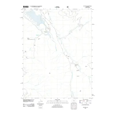
2011 Map of Ute Peak
USGS Topo · Published 2011About this map
The Williams Fork drainage in Grand County reveals a landscape shaped by both massive industrial mining infrastructure and high-altitude wilderness. At the center of the local economy is the Henderson Mill, connected to mining operations via the Henderson Tunnel. This industrial activity sits in contrast to the surrounding Williams Fork Mountains, where the Ute Creek Reservoir and East Branch Reservoir manage water along the creek systems. The small settlement of Leal serves as a waypoint along the river, near the Trails End Ranch. Toward the south, the topography rises toward prominent summits like Ute Peak, Sugarloaf, and Old Baldy, while recreational sites such as South Fork Campground and Sugarloaf Campground suggest the area's secondary role as a destination for forest visitors. The map clearly delineates the complex network of mountain roads, including Co RD 3 and Ute Pass Rd, which navigate the steep terrain of Ute Pass and Berry Gulch.
Find a feature on this map
37 named features on this map. Tap any name to fly to it.
Don’t see what you’re looking for? This feature index may not catch every label — zoom into the map to look around manually.
Map Details
Editions of this 2011 Ute Peak Map
This is the sole edition of this map. No revisions or reprints were ever made.
Other maps of this area

1924 · Montezuma
USGS Topo · 1:62,500

1924 · Fraser
USGS Topo · 1:62,500

1926 · Fraser
USGS Topo · 1:62,500

1926 · Montezuma
USGS Topo · 1:62,500

1929 · Dillon
USGS Topo · 1:62,500

1933 · Montezuma
USGS Topo · 1:62,500

1933 · Ute Peak
USGS Topo · 1:62,500

1934 · Dillon
USGS Topo · 1:62,500

1937 · Ute Peak
USGS Topo · 1:62,500

1953 · Denver
USGS Topo · 1:250,000