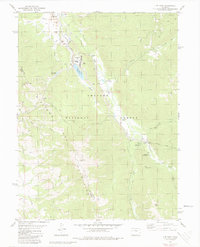
1980 Map of Ute Peak
USGS Topo · Published 1980About this map
The industrial infrastructure of the Henderson Mill and its associated water management systems dominate the high-altitude landscape of the Williams Fork Mountains in the late 1970s. This survey details an intricate network of resource extraction and transport, including a massive Tailings Pond, an aboveground aqueduct, and several siphons and pipelines that move water across the peaks. The environmental impact of these operations is juxtaposed with the protected lands of the Arapaho National Forest, where recreational sites like South Fork Campground and Sugarloaf Campground are situated near the confluence of the South Fork and Williams Fork rivers.
Find a feature on this map
34 named features on this map. Tap any name to fly to it.
Don’t see what you’re looking for? This feature index may not catch every label — zoom into the map to look around manually.
Map Details
Editions of this 1980 Ute Peak Map
2 editions found
Other maps of this area

1924 · Montezuma
USGS Topo · 1:62,500

1924 · Fraser
USGS Topo · 1:62,500

1926 · Fraser
USGS Topo · 1:62,500

1926 · Montezuma
USGS Topo · 1:62,500

1929 · Dillon
USGS Topo · 1:62,500

1933 · Montezuma
USGS Topo · 1:62,500

1933 · Ute Peak
USGS Topo · 1:62,500

1934 · Dillon
USGS Topo · 1:62,500

1937 · Ute Peak
USGS Topo · 1:62,500

1953 · Denver
USGS Topo · 1:250,000