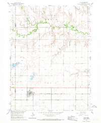
1966 Map of Utica
USGS Topo · Published 1967About this map
The village of Utica serves as the central hub of this mid-1960s agricultural landscape, situated along the Chicago Burlington and Quincy railroad line. The map reveals a highly structured rural environment where section lines dictate the placement of farmsteads and rural infrastructure. Local genealogy is anchored by the Emmanuel Ch and several burial sites, including the Dry Creek Cem and DeWitt Cem, which reflect the early settlement patterns across the Stewart and Waco townships.
Find a feature on this map
20 named features on this map. Tap any name to fly to it.
Don’t see what you’re looking for? This feature index may not catch every label — zoom into the map to look around manually.
Map Details
Editions of this 1966 Utica Map
This is the sole edition of this map. No revisions or reprints were ever made.
Other maps of this area

1899 · David City
USGS Topo · 1:125,000

1934 · Seward
USGS Topo · 1:48,000

1934 · Utica
USGS Topo · 1:62,500

1937 · Utica
USGS Topo · 1:62,500

1939 · Seward
USGS Topo · 1:62,500

1955 · Fremont
USGS Topo · 1:250,000

1955 · Lincoln
USGS Topo · 1:250,000

1957 · Fremont
USGS Topo · 1:250,000

1957 · Lincoln
USGS Topo · 1:250,000

1958 · Fremont
USGS Topo · 1:250,000