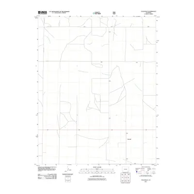
2011 Map of Utleyville
USGS Topo · Published 2011About this map
Utleyville stands as a focal point in this high-plains landscape, where the grid of rural roads meets a network of ephemeral drainage systems. The settlement is positioned north of the South Fork Sand Arroyo, highlighting the importance of water access in this arid stretch of Baca County. The terrain is defined by the winding paths of the North Fork Sand Arroyo and Soldier Creek, which cut through the open country. These natural watercourses dictated the placement of early routes like County Rd 223 and Co Rd 48. The map documents the persistent rural character of the area, where large-scale ranching or farming plots are bounded by precise county road demarcations, such as County Rd 52 along the northern edge. This survey provides a clear look at the sparsely populated region at the start of the 2010s, showing the intersection of natural arroyos and modern transportation infrastructure.
Find a feature on this map
8 named features on this map. Tap any name to fly to it.
Don’t see what you’re looking for? This feature index may not catch every label — zoom into the map to look around manually.
Map Details
Editions of this 2011 Utleyville Map
This is the sole edition of this map. No revisions or reprints were ever made.
Other maps of this area

1891 · Springfield
USGS Topo · 1:125,000

1892 · Mt Carrizo
USGS Topo · 1:125,000

1893 · Springfield
USGS Topo · 1:125,000

1955 · La Junta
USGS Topo · 1:250,000

1958 · La Junta
USGS Topo · 1:250,000

1968 · La Junta
USGS Topo · 1:250,000

1978 · Pintada Creek
USGS Topo · 1:24,000

1978 · Utleyville
USGS Topo · 1:24,000
1978 · Lone Rock
USGS Topo · 1:24,000
1978 · Pritchett NW
USGS Topo · 1:24,000