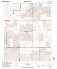
1996 Map of Utleyville
USGS Topo · Published 2000About this map
Comanche National Grassland dominates this high-plains landscape in southeastern Colorado, where the transition from ranching to conservation is marked by sprawling public lands and sparse residential clusters. The settlement of Utleyville serves as a small anchor along the southern reaches, while the isolated site of Martin appears to the northwest near the winding course of Little Mustang Creek. The terrain is defined by dry-land water features and canyons, including Cat Canyon and the branching drainage of North Fork and South Fork Sand Arroyo. Utility corridors and pipelines cut across the topography, highlighting the region's role in resource transport. Evidence of local industry is visible in scattered Gravel Pits, while the presence of a Stock Tank and various wells underscores the continuous importance of water management in this arid grazing environment.
Find a feature on this map
13 named features on this map. Tap any name to fly to it.
Don’t see what you’re looking for? This feature index may not catch every label — zoom into the map to look around manually.
Map Details
Editions of this 1996 Utleyville Map
This is the sole edition of this map. No revisions or reprints were ever made.
Other maps of this area

1891 · Springfield
USGS Topo · 1:125,000

1892 · Mt Carrizo
USGS Topo · 1:125,000

1893 · Springfield
USGS Topo · 1:125,000

1955 · La Junta
USGS Topo · 1:250,000

1958 · La Junta
USGS Topo · 1:250,000

1968 · La Junta
USGS Topo · 1:250,000

1978 · Pintada Creek
USGS Topo · 1:24,000

1978 · Utleyville
USGS Topo · 1:24,000
1978 · Lone Rock
USGS Topo · 1:24,000
1978 · Pritchett NW
USGS Topo · 1:24,000