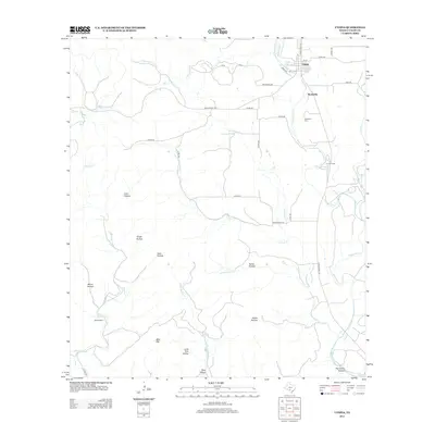
2013 Map of Utopia
USGS Topo · Published 2013About this map
Utopia and the nearby settlement of Waresville anchor this landscape where the Sabinal River and W Sabinal River converge. The topography is defined by a dense network of seasonal creek beds and named hollows, including Lynn Hollow, Grape Hollow, and Indian Hollow, which drain the elevated terrain of Seco Ridge and Bald Mtn. This 2013 survey illustrates a rural Texas environment where local ranching and recreation coexist, highlighted by the Blanco Ranch to the southwest and La Jita Camp along the river. Genealogists and local historians can trace the connectivity of the region through established routes like Ranch Road 187 and Ranch Road 1050, while the Waresville Cem stands as a primary site for family history research in this part of Uvalde County.
Find a feature on this map
41 named features on this map. Tap any name to fly to it.
Don’t see what you’re looking for? This feature index may not catch every label — zoom into the map to look around manually.
Map Details
Editions of this 2013 Utopia Map
This is the sole edition of this map. No revisions or reprints were ever made.
Other maps of this area

1898 · Uvalde
USGS Topo · 1:125,000

1899 · Uvalde
USGS Topo · 1:125,000

1954 · San Antonio
USGS Topo · 1:250,000

1956 · Sabinal
USGS Topo · 1:62,500

1956 · Tarpley
USGS Topo · 1:62,500

1956 · Utopia
USGS Topo · 1:62,500

1957 · San Antonio
USGS Topo · 1:250,000

1960 · Concan
USGS Topo · 1:24,000

1960 · Magers Crossing
USGS Topo · 1:24,000
1964 · Seco Pass
USGS Topo · 1:24,000