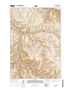
2014 Map of Utts Butte
USGS Topo · Published 2014About this map
Utts Butte serves as a prominent landmark in this high-desert landscape of Morrow County, where a complex network of deep drainage systems defines the terrain. The map illustrates a rural area characterized by numerous named canyons, including Fourmile Canyon, Ely Canyon, and Kincaid Canyon, which intersect the high plateaus. Human activity is marked by a sparse but deliberate grid of roads and tracks such as Smith Rd and Halversen Ln, reflecting the extensive land management practices of the early 21st century. The southeastern portion of the map features the Rattlesnake Grade, a notable topographic transition near Baker Canyon. Along the southern border, Eightmile Canyon and its associated Eight Mile Rd provide a corridor through the undulating hills, while the Ione Gooseberry Rd suggests regional connections to the surrounding ranching and farming communities.
Find a feature on this map
31 named features on this map. Tap any name to fly to it.
Don’t see what you’re looking for? This feature index may not catch every label — zoom into the map to look around manually.
Map Details
Editions of this 2014 Utts Butte Map
This is the sole edition of this map. No revisions or reprints were ever made.
Other maps of this area
1906 · Blalock Island
USGS Topo · 1:125,000
1908 · Blalock Island
USGS Topo · 1:125,000
1916 · Arlington
USGS Topo · 1:125,000
1916 · Condon
USGS Topo · 1:125,000

1953 · Pendleton
USGS Topo · 1:250,000

1953 · The Dalles
USGS Topo · 1:250,000

1956 · The Dalles
USGS Topo · 1:250,000

1956 · Pendleton
USGS Topo · 1:250,000
1957 · The Dalles
USGS Topo · 1:250,000
1964 · Hickland Butte
USGS Topo · 1:24,000