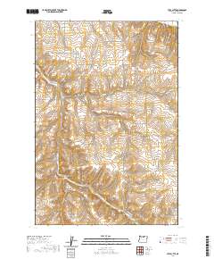
2020 Map of Utts Butte
USGS Topo · Published 2020About this map
Utts Butte stands as a prominent landmark in this section of Morrow County, where the high desert landscape is deeply incised by a network of drainage systems. The terrain is characterized by long, winding coulees such as Eightmile Canyon and Fourmile Canyon in the north, which give way to Youngs Canyon and Davis Canyon further south. This 2020 survey reveals a rural infrastructure of namesake roads and lanes that follow the natural topography, including Kincaid Ln and Halvorsen Ln. To the southeast, the steep descent of Rattlesnake Grade provides a clear view of the elevation changes near Baker Canyon. The map records a modern snapshot of land management and access, preserving the specific family and place names associated with these ridges and draws.
Find a feature on this map
31 named features on this map. Tap any name to fly to it.
Don’t see what you’re looking for? This feature index may not catch every label — zoom into the map to look around manually.
Map Details
Editions of this 2020 Utts Butte Map
This is the sole edition of this map. No revisions or reprints were ever made.
Other maps of this area
1906 · Blalock Island
USGS Topo · 1:125,000
1908 · Blalock Island
USGS Topo · 1:125,000
1916 · Arlington
USGS Topo · 1:125,000
1916 · Condon
USGS Topo · 1:125,000

1953 · Pendleton
USGS Topo · 1:250,000

1953 · The Dalles
USGS Topo · 1:250,000

1956 · The Dalles
USGS Topo · 1:250,000

1956 · Pendleton
USGS Topo · 1:250,000
1957 · The Dalles
USGS Topo · 1:250,000
1964 · Hickland Butte
USGS Topo · 1:24,000