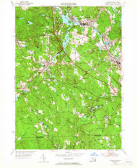
1953 Map of Uxbridge
USGS Topo · Published 1965About this map
Industrial and rural landscapes converge along the Mumford River and Blackstone River in the mid-century. This 1953 revision shows the dense textile-mill era footprints of Whitinsville and Uxbridge, where workers lived in neighborhoods like New Village. The transportation network is dominated by the New York New Haven and Hartford RR, with key stops at East Douglas Sta and Linwood. Away from the river valleys, the terrain rises into the Sutton State Forest and the heights of Bald Hill. Numerous family and community landmarks are preserved here, including the Aldrich Cem, Lapham Cem, and the historic Halfway House located along the old Hartford Ave route. The map also records the remnants of the Blackstone Canal and various local educational sites such as the Aldrich Sch and Tasseltop Sch, reflecting the established social fabric of the Blackstone Valley during this period of New England history.
Find a feature on this map
113 named features on this map. Tap any name to fly to it.
Don’t see what you’re looking for? This feature index may not catch every label — zoom into the map to look around manually.
Map Details
Editions of this 1953 Uxbridge Map
3 editions found
Other maps of this area

1886 · Blackstone
USGS Topo · 1:62,500

1889 · Blackstone
USGS Topo · 1:62,500

1889 · Webster
USGS Topo · 1:62,500

1889 · Putnam
USGS Topo · 1:62,500

1889 · Burrillville
USGS Topo · 1:62,500

1892 · Webster
USGS Topo · 1:62,500

1893 · Putnam
USGS Topo · 1:62,500

1893 · Blackstone
USGS Topo · 1:62,500

1894 · Burrillville
USGS Topo · 1:62,500

1900 · Blackstone
USGS Topo · 1:62,500