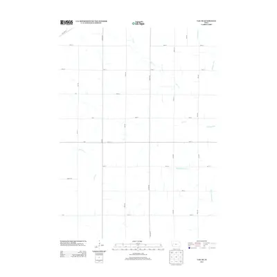
2013 Map of Vail NE
USGS Topo · Published 2013About this map
The Middle Raccoon River and Lime Cr carve winding paths through this section of Carroll County, defining a landscape dominated by the geometry of the Public Land Survey System. The map reveals a strictly maintained grid of rural infrastructure, where family-named thoroughfares like Otter Ave, Perkins Ave, and Concord Ave facilitate movement between agricultural plots. Water management is a central theme of the terrain, visible in the presence of the Wall Lake Inlet in the northeastern corner and the various tributaries such as Beamon Cr that feed into the larger river system. This 2013 survey reflects the modern organization of the Iowa countryside, preserving the names of the local avenues and streets that have served the region's farming communities for generations.
Find a feature on this map
29 named features on this map. Tap any name to fly to it.
Don’t see what you’re looking for? This feature index may not catch every label — zoom into the map to look around manually.
Map Details
Editions of this 2013 Vail NE Map
This is the sole edition of this map. No revisions or reprints were ever made.
Other maps of this area

1954 · Fort Dodge
USGS Topo · 1:250,000

1957 · Fort Dodge
USGS Topo · 1:250,000

1958 · Fort Dodge
USGS Topo · 1:250,000

1980 · Odebolt East
USGS Topo · 1:24,000

1980 · Breda
USGS Topo · 1:24,000

1980 · Grant City
USGS Topo · 1:24,000

1980 · Lake View
USGS Topo · 1:24,000

1980 · Boyer
USGS Topo · 1:24,000
1980 · Carroll West
USGS Topo · 1:24,000
1980 · Vail NE
USGS Topo · 1:24,000