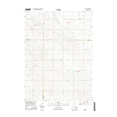
2015 Map of Vail NE
USGS Topo · Published 2015About this map
The Middle Raccoon River and Lime Cr drainage basins define the rural landscape at the intersection of Carroll, Crawford, and Sac counties. This agricultural region is meticulously divided by a grid of section lines and gravel routes, including Co Hwy M64 and Co Hwy M27, which provide the primary north-south infrastructure for the local farming community. The map preserves the locations of several community burial grounds, such as South Wall Lake Cem in the north and Wheatland Cem further south, which serve as historical anchors for the surrounding farmsteads. Significant hydrological features like the Wall Lake Inlet and the meandering Beamon Cr indicate the natural water management patterns that have shaped land use in this part of western Iowa.
Find a feature on this map
39 named features on this map. Tap any name to fly to it.
Don’t see what you’re looking for? This feature index may not catch every label — zoom into the map to look around manually.
Map Details
Editions of this 2015 Vail NE Map
This is the sole edition of this map. No revisions or reprints were ever made.
Other maps of this area

1954 · Fort Dodge
USGS Topo · 1:250,000

1957 · Fort Dodge
USGS Topo · 1:250,000

1958 · Fort Dodge
USGS Topo · 1:250,000

1980 · Odebolt East
USGS Topo · 1:24,000

1980 · Breda
USGS Topo · 1:24,000

1980 · Grant City
USGS Topo · 1:24,000

1980 · Lake View
USGS Topo · 1:24,000

1980 · Boyer
USGS Topo · 1:24,000
1980 · Carroll West
USGS Topo · 1:24,000
1980 · Vail NE
USGS Topo · 1:24,000