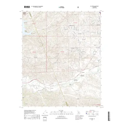
2018 Map of Val Verde
USGS Topo · Published 2018About this map
Val Verde and the surrounding canyon country of the Angeles National Forest are defined by a complex network of ephemeral drainages and ridgelines. The settlement of Val Verde itself sits at the confluence of several canyons, with its residential grid extending along Val Verde Rd and Lexington Dr. To the southeast, the broader valley of the Santa Clara River facilitates major transportation routes like Henry Mayo Dr and provides a natural corridor for the community of Del Valle. The terrain transitions from the steep slopes of Oak Ridge in the south to the reservoir edges of Lake Piru in the west, illustrating the geographical constraints on development in this portion of the Santa Clarita Valley. Numerous fire roads and mountain ways, such as Loma Verde Mountainway and Santo Felicia Fire Rd, crisscross the high ground between Holser Canyon and Hasley Canyon, tracing the remote paths used for forest management and utility access.
Find a feature on this map
98 named features on this map. Tap any name to fly to it.
Don’t see what you’re looking for? This feature index may not catch every label — zoom into the map to look around manually.
Map Details
Editions of this 2018 Val Verde Map
This is the sole edition of this map. No revisions or reprints were ever made.
Other maps of this area

1900 · Piru
USGS Topo · 1:62,500

1903 · Tejon
USGS Topo · 1:125,000

1903 · Camulos
USGS Topo · 1:125,000

1903 · Santa Susana
USGS Topo · 1:62,500

1921 · Piru
USGS Topo · 1:62,500
1929 · Pico
USGS Topo · 1:24,000

1931 · Whitaker Peak
USGS Topo · 1:24,000

1931 · Santa Felicia Canyon
USGS Topo · 1:24,000

1931 · Castaic
USGS Topo · 1:24,000

1935 · Santa Felicia Canyon
USGS Topo · 1:24,000