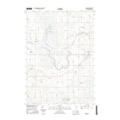
2015 Map of Valders
USGS Topo · Published 2015About this map
The Manitowoc River meanders through this landscape of Manitowoc County, where the village of Valders serves as a primary center for the surrounding agricultural area. Further west, the Collins Marsh Reservoir dominates the terrain, illustrating the significant role of water management and conservation in this part of Wisconsin. The smaller community of Collins sits just southwest of the reservoir, while St. Nazianz occupies the southern portion of the sheet near Lake Oschwald. A network of rural roads, including Poplar Grove Rd and Clarks Mills Rd, connects scattered farmsteads and points of local heritage. Genealogists will find several burial grounds documented, including Saint Peters Evangelical Lutheran Cem and Tyler Cem. The presence of Windhaven Airport and Quarry Lake further defines the modern use of the land, balancing local transport and industry with the natural drainage patterns of Mud Creek.
Find a feature on this map
84 named features on this map. Tap any name to fly to it.
Don’t see what you’re looking for? This feature index may not catch every label — zoom into the map to look around manually.
Map Details
Editions of this 2015 Valders Map
This is the sole edition of this map. No revisions or reprints were ever made.
Other maps of this area

1954 · School Hill
USGS Topo · 1:24,000

1954 · St. Wendel
USGS Topo · 1:24,000

1954 · Howards Grove
USGS Topo · 1:62,500

1954 · Chilton
USGS Topo · 1:62,500

1954 · Reedsville
USGS Topo · 1:62,500

1954 · Kiel
USGS Topo · 1:62,500

1954 · Milwaukee
USGS Topo · 1:250,000

1954 · Manitowoc
USGS Topo · 1:250,000

1955 · Green Bay
USGS Topo · 1:250,000

1957 · Madison
USGS Topo · 1:250,000