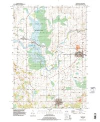
1992 Map of Valders
USGS Topo · Published 1996About this map
The Manitowoc River meanders across this landscape of Manitowoc County, where several distinct rural communities and natural preserves define the late twentieth-century character of the region. The northern half is dominated by the sprawling wetlands of the Collins State Wildlife Area, which sits just east of the village of Collins. To the south, the village of St Nazianz remains a significant local center, noted for the prominent St Nazianz Ch and its proximity to Lake Oschwald.
Find a feature on this map
50 named features on this map. Tap any name to fly to it.
Don’t see what you’re looking for? This feature index may not catch every label — zoom into the map to look around manually.
Map Details
Editions of this 1992 Valders Map
This is the sole edition of this map. No revisions or reprints were ever made.
Other maps of this area

1954 · School Hill
USGS Topo · 1:24,000

1954 · St. Wendel
USGS Topo · 1:24,000

1954 · Howards Grove
USGS Topo · 1:62,500

1954 · Chilton
USGS Topo · 1:62,500

1954 · Reedsville
USGS Topo · 1:62,500

1954 · Kiel
USGS Topo · 1:62,500

1954 · Milwaukee
USGS Topo · 1:250,000

1954 · Manitowoc
USGS Topo · 1:250,000

1955 · Green Bay
USGS Topo · 1:250,000

1957 · Madison
USGS Topo · 1:250,000