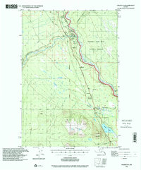
1996 Map of Valdez D-4
USGS Topo · Published 2001About this map
Copper Center sits at the vital confluence of the Klutina River and the Copper River, serving as a historic hub for travel and transport in the interior. This map illustrates the junction where the Richardson Highway and Edgerton Line Highway meet, highlighting the area's importance as a gateway to the Wrangell Saint Elias National Preserve. The landscape is dominated by significant water systems, including the Tazlina River and the Klawasi River, which carve through the terrain near peaks like Stuck Mountain and Willow Mountain. Modern infrastructure is represented by the Trans Alaska Pipeline, which traverses the valley alongside older survey markers such as the Copper River Meridian and Base Line. Notable landmarks include a Campground, a Gravel Pit, and various Cabins that dot the riverbanks.
Find a feature on this map
35 named features on this map. Tap any name to fly to it.
Don’t see what you’re looking for? This feature index may not catch every label — zoom into the map to look around manually.
Map Details
Editions of this 1996 Valdez D-4 Map
This is the sole edition of this map. No revisions or reprints were ever made.
Other maps of this area

1948 · Valdez D-5
USGS Topo · 1:63,360

1949 · Gulkana A-3
USGS Topo · 1:63,360

1949 · Valdez D-4
USGS Topo · 1:63,360

1951 · Valdez D-5
USGS Topo · 1:63,360

1951 · Gulkana
USGS Topo · 1:250,000

1951 · Gulkana A-4
USGS Topo · 1:63,360

1951 · Valdez C-3
USGS Topo · 1:63,360

1951 · Valdez C-4
USGS Topo · 1:63,360

1951 · Valdez C-5
USGS Topo · 1:63,360

1952 · Gulkana A-3
USGS Topo · 1:63,360