
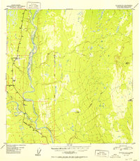
1952 Map of Gulkana A-3
USGS Topo · Published 1952About this map
The Copper River and its major tributaries dominate this subarctic landscape at a time of growing transportation infrastructure in the Alaska Interior. The confluence where the Tazlina River joins from the west marks a strategic junction for the region's early road network. Modern travel is represented by the intersection of the Richardson Highway and the Glenn Highway, which provide access to remote outposts such as Gateway Lodge.
Find a feature on this map
23 named features on this map. Tap any name to fly to it.
Don’t see what you’re looking for? This feature index may not catch every label — zoom into the map to look around manually.
Map Details
Editions of this 1952 Gulkana A-3 Map
2 editions found
Other maps of this area

1948 · Valdez D-5
USGS Topo · 1:63,360

1949 · Gulkana A-3
USGS Topo · 1:63,360

1949 · Valdez D-4
USGS Topo · 1:63,360

1949 · Gulkana B-2
USGS Topo · 1:63,360

1950 · Gulkana B-3
USGS Topo · 1:63,360

1951 · Valdez D-5
USGS Topo · 1:63,360

1951 · Gulkana
USGS Topo · 1:250,000

1951 · Gulkana A-4
USGS Topo · 1:63,360

1951 · Gulkana B-4
USGS Topo · 1:63,360

1952 · Valdez
USGS Topo · 1:250,000