
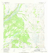
1949 Map of Gulkana B-2
USGS Topo · Published 1965About this map
The Copper River and Sanford River dominate this interior landscape, shown shortly after the Second World War when much of the surrounding terrain remained unsurveyed and unmarked. The Glenn Highway follows the western bank of the Copper River, providing a vital land link through the valley. This 1949 survey illustrates the complex drainage patterns of the region, where the Tulsona Creek and Little Tulsona Creek feed into the larger glacial river systems. To the north, the terrain transitions into a lake-studded plateau containing Billy Lake and the Yukeda Lakes. Survey points like Vabm 1796 Cliff serve as the primary landmarks in a territory characterized by extensive wetlands and seasonal swamps interpreted from aerial photography.
Find a feature on this map
10 named features on this map. Tap any name to fly to it.
Don’t see what you’re looking for? This feature index may not catch every label — zoom into the map to look around manually.
Map Details
Editions of this 1949 Gulkana B-2 Map
2 editions found
Other maps of this area

1949 · Gulkana A-3
USGS Topo · 1:63,360

1949 · Gulkana C-2
USGS Topo · 1:63,360

1949 · Gulkana C-1
USGS Topo · 1:63,360

1950 · Gulkana B-3
USGS Topo · 1:63,360

1950 · Gulkana C-3
USGS Topo · 1:63,360

1951 · Gulkana
USGS Topo · 1:250,000

1952 · Gulkana A-3
USGS Topo · 1:63,360

1952 · Gulkana B-3
USGS Topo · 1:63,360

1952 · Gulkana B-2
USGS Topo · 1:63,360

1952 · Gulkana C-2
USGS Topo · 1:63,360