
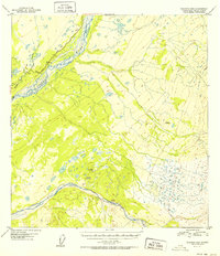
1952 Map of Gulkana B-2
USGS Topo · Published 1952About this map
The braided waters of the Copper River and Sanford River dominate this 1949 aerial survey of the Gulkana region. The landscape is defined by the complex glacial outwash patterns of these major waterways, where shifting channels and gravel bars create a dynamic riverine environment. Along the northwestern edge, the Glenn Highway provides the primary overland corridor, following the higher ground above the river valley. This transportation route parallels several watercourses, including Tulsona Creek and Little Tulsona Creek, which drain the surrounding highlands. Survey markers like VABM Cliff and VABM Sanford denote significant elevation points across the terrain, reflecting the early postwar efforts by the Geological Survey to map the Alaskan interior using multiplex methods and aerial photography.
Find a feature on this map
8 named features on this map. Tap any name to fly to it.
Don’t see what you’re looking for? This feature index may not catch every label — zoom into the map to look around manually.
Map Details
Editions of this 1952 Gulkana B-2 Map
2 editions found
Other maps of this area

1949 · Gulkana A-3
USGS Topo · 1:63,360

1949 · Gulkana C-2
USGS Topo · 1:63,360

1949 · Gulkana B-2
USGS Topo · 1:63,360

1949 · Gulkana C-1
USGS Topo · 1:63,360

1950 · Gulkana B-3
USGS Topo · 1:63,360

1950 · Gulkana C-3
USGS Topo · 1:63,360

1951 · Gulkana
USGS Topo · 1:250,000

1952 · Gulkana A-3
USGS Topo · 1:63,360

1952 · Gulkana B-3
USGS Topo · 1:63,360

1952 · Gulkana C-2
USGS Topo · 1:63,360