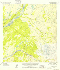
1952 Map of Gulkana B-2
USGS Topo · Published 1952About this map
The braided channels of the Copper River dominate this interior Alaskan landscape, meeting the Sanford River as it flows from the east. This 1952 survey, based on aerial photography from 1949, documents a time when the Glenn Highway served as a primary artery through the wilderness, hugging the riverbanks and connecting surveyors to benchmarks like Vabm 1796. The terrain is characterized by complex hydrography, including the winding paths of Tulsona Creek and Little Tulsona Creek. Geodetic control points such as VABM Mid 2917 and Vabm 2601 stand as landmarks for researchers tracking early territorial mapping efforts. The map reveals the relationship between the major river systems and the limited road infrastructure in the Third Judicial Division during the mid-twentieth century.
Find a feature on this map
8 named features on this map. Tap any name to fly to it.
Don’t see what you’re looking for? This feature index may not catch every label — zoom into the map to look around manually.
Map Details
Editions of this 1952 Gulkana B-2 Map
2 editions found
Other maps of this area

1949 · Gulkana A-3
USGS Topo · 1:63,360

1949 · Gulkana C-2
USGS Topo · 1:63,360

1949 · Gulkana B-2
USGS Topo · 1:63,360

1949 · Gulkana C-1
USGS Topo · 1:63,360

1950 · Gulkana B-3
USGS Topo · 1:63,360

1950 · Gulkana C-3
USGS Topo · 1:63,360

1951 · Gulkana
USGS Topo · 1:250,000

1952 · Gulkana A-3
USGS Topo · 1:63,360

1952 · Gulkana B-3
USGS Topo · 1:63,360

1952 · Gulkana B-2
USGS Topo · 1:63,360