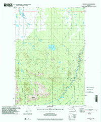
1996 Map of Valdez D-5
USGS Topo · Published 2001About this map
The Klutina River flows through this interior landscape, carving a prominent path toward the southeast as it passes through the dramatic narrows of The Gorge. Topography here is dominated by high summits including Mt Carter, Sunny Peak, and Dowling Peak, which define the southern mountain ranges. To the north, the terrain transitions into a lake-dotted basin characterized by Hudson Lake and numerous smaller, unnamed water bodies.
Find a feature on this map
14 named features on this map. Tap any name to fly to it.
Don’t see what you’re looking for? This feature index may not catch every label — zoom into the map to look around manually.
Map Details
Editions of this 1996 Valdez D-5 Map
This is the sole edition of this map. No revisions or reprints were ever made.
Other maps of this area

1948 · Valdez D-5
USGS Topo · 1:63,360

1949 · Gulkana A-3
USGS Topo · 1:63,360

1949 · Valdez D-4
USGS Topo · 1:63,360

1949 · Valdez D-6
USGS Topo · 1:63,360

1950 · Valdez C-6
USGS Topo · 1:63,360

1951 · Valdez D-5
USGS Topo · 1:63,360

1951 · Gulkana
USGS Topo · 1:250,000

1951 · Valdez D-6
USGS Topo · 1:63,360

1951 · Gulkana A-4
USGS Topo · 1:63,360

1951 · Valdez C-4
USGS Topo · 1:63,360