
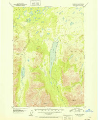
1951 Map of Valdez D-6
USGS Topo · Published 1951About this map
Saint Anne Lake dominates the central landscape of this 1951 topographical study, serving as a primary hydrological focal point for the surrounding high-elevation terrain. This survey reflects a period of systematic mapping by the U.S. Geological Survey using aerial photography from 1948, capturing the intricate drainage patterns of the area before modern developments. To the west, the glacial waters of Kaina Lake feed into Kaina Creek, while the eastern portion of the quadrangle is defined by the steep rises of Cranberry Peak and VABM Anne 3649. The map provides an essential baseline of the Alaskan wilderness during the mid-twentieth century, tracing the serpentine routes of Saint Anne Creek and Nikolai Creek through the valleys south of Wests Peak.
Find a feature on this map
9 named features on this map. Tap any name to fly to it.
Don’t see what you’re looking for? This feature index may not catch every label — zoom into the map to look around manually.
Map Details
Editions of this 1951 Valdez D-6 Map
2 editions found
Other maps of this area

1948 · Valdez D-5
USGS Topo · 1:63,360

1949 · Gulkana A-5
USGS Topo · 1:63,360

1949 · Valdez D-6
USGS Topo · 1:63,360

1949 · Valdez D-7
USGS Topo · 1:63,360

1950 · Valdez C-6
USGS Topo · 1:63,360

1951 · Valdez D-5
USGS Topo · 1:63,360

1951 · Gulkana
USGS Topo · 1:250,000

1951 · Valdez D-7
USGS Topo · 1:63,360

1951 · Gulkana A-4
USGS Topo · 1:63,360

1951 · Valdez C-5
USGS Topo · 1:63,360