
1950 Map of Valdez C-6
USGS Topo · Published 1966About this map
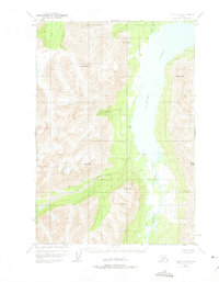
Klutina Lake dominates this glacial landscape, serving as a massive basin for the surrounding alpine drainage systems in the years following World War II. The terrain is characterized by a network of steep mountains and ridges, including Powell Peak and Marshall Mtn, which feed into the central waterway. The braided channels of the Klutina River enter from the south, creating a complex delta where it meets the lake, while the Hallet River carves a narrow path between Terrace Mtn and Mayer Peak. Although human infrastructure is nearly absent from this mid-century survey, a solitary Cabin situated on the western shore of the lake and another near the northern outflow suggest a landscape utilized by seasonal trappers or early backcountry explorers. This 1950 photogrammetric data captures the untouched state of the interior before more extensive modern recreational access or infrastructure arrived in the region.
Find a feature on this map
15 named features on this map. Tap any name to fly to it.
Don’t see what you’re looking for? This feature index may not catch every label — zoom into the map to look around manually.
Map Details
Editions of this 1950 Valdez C-6 Map
2 editions found
Other maps of this area

1948 · Valdez D-5
USGS Topo · 1:63,360

1949 · Valdez D-6
USGS Topo · 1:63,360

1949 · Valdez D-7
USGS Topo · 1:63,360

1951 · Valdez D-5
USGS Topo · 1:63,360

1951 · Valdez D-6
USGS Topo · 1:63,360

1951 · Valdez D-7
USGS Topo · 1:63,360

1951 · Valdez B-5
USGS Topo · 1:63,360

1951 · Valdez C-5
USGS Topo · 1:63,360

1951 · Valdez B-6
USGS Topo · 1:63,360

1952 · Valdez
USGS Topo · 1:250,000