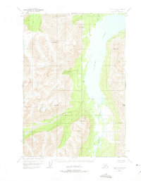
1950 Map of Valdez C-6
USGS Topo · Published 1975About this map
Klutina Lake dominates this mid-century Alaskan landscape, serving as the central reservoir for the Klutina River which drains southward through a glacial valley. The 1950 aerial photography reveals a wilderness defined by massive peaks and high-elevation drainages, with the Hallet River cutting a deep path from the west. Human presence is minimal, noted only by a few isolated Cabin sites along the lake's western shore and near the mouth of St Anne Cr. These structures likely served early trappers or prospectors navigating the Chugach Mountains before the era of modern development. Geologically significant summits such as Terrace Mtn, Mayer Peak, and Powell Peak frame the basin, while Curtis Gulch provides a break in the steep western ridges. The lack of roads or established trails reinforces the area's character as a frontier environment accessible primarily by water or air.
Find a feature on this map
15 named features on this map. Tap any name to fly to it.
Don’t see what you’re looking for? This feature index may not catch every label — zoom into the map to look around manually.
Map Details
Editions of this 1950 Valdez C-6 Map
2 editions found
Other maps of this area

1948 · Valdez D-5
USGS Topo · 1:63,360

1949 · Valdez D-6
USGS Topo · 1:63,360

1949 · Valdez D-7
USGS Topo · 1:63,360

1950 · Valdez C-6
USGS Topo · 1:63,360

1951 · Valdez D-5
USGS Topo · 1:63,360

1951 · Valdez D-6
USGS Topo · 1:63,360

1951 · Valdez D-7
USGS Topo · 1:63,360

1951 · Valdez B-5
USGS Topo · 1:63,360

1951 · Valdez C-5
USGS Topo · 1:63,360

1951 · Valdez B-6
USGS Topo · 1:63,360