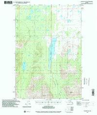
1993 Map of Valdez D-6
USGS Topo · Published 2001About this map
Saint Anne Lake dominates the central corridor of this interior Alaskan landscape, serving as a primary hydrological landmark between the surrounding peaks. To the west, the waters of Kaina Lake and Kaina Creek drain the high country, while the southern reaches are defined by the sharp elevations of Wests Peak and Cranberry Peak. These summits overlook a network of drainage systems including Cranberry Creek and Marsh Creek, which navigate the transitional terrain between the mountains and the valley floors.
Find a feature on this map
12 named features on this map. Tap any name to fly to it.
Don’t see what you’re looking for? This feature index may not catch every label — zoom into the map to look around manually.
Map Details
Editions of this 1993 Valdez D-6 Map
This is the sole edition of this map. No revisions or reprints were ever made.
Other maps of this area

1948 · Valdez D-5
USGS Topo · 1:63,360

1949 · Gulkana A-5
USGS Topo · 1:63,360

1949 · Valdez D-6
USGS Topo · 1:63,360

1949 · Valdez D-7
USGS Topo · 1:63,360

1950 · Valdez C-6
USGS Topo · 1:63,360

1951 · Valdez D-5
USGS Topo · 1:63,360

1951 · Gulkana
USGS Topo · 1:250,000

1951 · Valdez D-6
USGS Topo · 1:63,360

1951 · Valdez D-7
USGS Topo · 1:63,360

1951 · Gulkana A-4
USGS Topo · 1:63,360