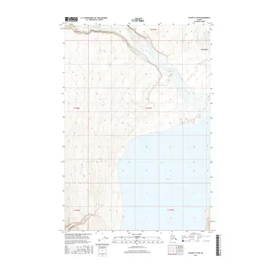
2016 Map of Valdez D-7 NW
USGS Topo · Published 2016About this map
Nelchina River winds through the northern landscape of this interior Alaskan territory, where the terrain shifts toward the expansive waters of Tazlina Lake to the south. The settlement of Mendeltna occupies a position near the northeastern corner, providing a rare point of named human habitation in an area otherwise defined by dramatic elevation changes and a dense network of watercourses. This 2016 survey illustrates the intersection of several township boundaries, including t3n r7w and t2n r7w, which organize the remote drainage basins and glacial lake systems. The transition from the river valley to the broad shoreline of the lake highlights the complex hydrology of the Unorganized Borough, where traditional land divisions meet the natural features of the Copper River basin.
Find a feature on this map
9 named features on this map. Tap any name to fly to it.
Don’t see what you’re looking for? This feature index may not catch every label — zoom into the map to look around manually.
Map Details
Editions of this 2016 Valdez D-7 NW Map
This is the sole edition of this map. No revisions or reprints were ever made.
Other maps of this area

1949 · Gulkana A-5
USGS Topo · 1:63,360

1949 · Gulkana A-6
USGS Topo · 1:63,360

1949 · Valdez D-8
USGS Topo · 1:63,360

1949 · Valdez D-7
USGS Topo · 1:63,360

1951 · Gulkana
USGS Topo · 1:250,000

1951 · Valdez D-7
USGS Topo · 1:63,360

1952 · Valdez D-8
USGS Topo · 1:63,360

1952 · Valdez
USGS Topo · 1:250,000

1952 · Gulkana A-5
USGS Topo · 1:63,360
1952 · Gulkana A-6
USGS Topo · 1:63,360