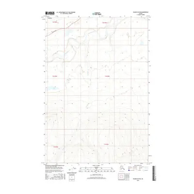
2016 Map of Valdez D-8 NE
USGS Topo · Published 2016About this map
Nelchina sits at the northern edge of this high-latitude terrain, where the Glenn Highway provides the primary transit corridor across the interior. The landscape is defined by the winding course of the Nelchina River, which flows through a wide valley in the northern sections before the topography rises sharply to the south into high ridges and peaks. In the central part of the survey, the Twin Lakes and the drainage of Bottley Cr mark the transition between the river flats and the upland elevations. This 2016 data captures the area's modern infrastructure and drainage patterns, showing how the road system hugs the contours of the valley while large portions of the surrounding territory remain dominated by natural water systems and significant elevation changes.
Find a feature on this map
11 named features on this map. Tap any name to fly to it.
Don’t see what you’re looking for? This feature index may not catch every label — zoom into the map to look around manually.
Map Details
Editions of this 2016 Valdez D-8 NE Map
This is the sole edition of this map. No revisions or reprints were ever made.
Other maps of this area

1949 · Gulkana A-6
USGS Topo · 1:63,360

1949 · Valdez D-8
USGS Topo · 1:63,360

1949 · Valdez D-7
USGS Topo · 1:63,360

1951 · Gulkana
USGS Topo · 1:250,000

1951 · Valdez D-7
USGS Topo · 1:63,360

1952 · Valdez D-8
USGS Topo · 1:63,360

1952 · Valdez
USGS Topo · 1:250,000
1952 · Gulkana A-6
USGS Topo · 1:63,360

1959 · Gulkana
USGS Topo · 1:250,000

1960 · Valdez
USGS Topo · 1:250,000