
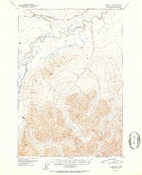
1952 Map of Valdez D-8
USGS Topo · Published 1952About this map
The Little Nelchina River and the larger Nelchina River dominate this interior Alaskan landscape, which was surveyed using aerial photography from 1948. This map captures the region at a time when the Glenn Highway was the primary corridor through the northern section, passing by Mile 140. The topography is marked by several significant peaks, identified by triangulation stations such as VABM Black 5854 and VABM Shale 4822, which overlook the expansive waters of Twin Lakes. A solitary Cabin located near the riverbank suggests the isolated nature of human settlement in this sub-arctic environment during the early 1950s. The map illustrates the complex drainage patterns of the river system as it winds through the high-elevation terrain of the Matanuska-Susitna area.
Find a feature on this map
15 named features on this map. Tap any name to fly to it.
Don’t see what you’re looking for? This feature index may not catch every label — zoom into the map to look around manually.
Map Details
Editions of this 1952 Valdez D-8 Map
2 editions found
Other maps of this area

1948 · Anchorage D-1
USGS Topo · 1:63,360

1949 · Talkeetna Mountains A-1
USGS Topo · 1:63,360

1949 · Gulkana A-6
USGS Topo · 1:63,360

1949 · Valdez D-8
USGS Topo · 1:63,360

1949 · Valdez D-7
USGS Topo · 1:63,360

1950 · Talkeetna Mountains
USGS Topo · 1:250,000

1951 · Gulkana
USGS Topo · 1:250,000

1951 · Valdez D-7
USGS Topo · 1:63,360

1951 · Anchorage
USGS Topo · 1:250,000

1951 · Anchorage D-1
USGS Topo · 1:63,360