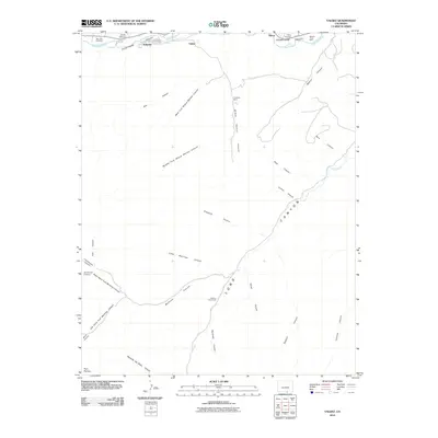
2010 Map of Valdez
USGS Topo · Published 2010About this map
The Purgatoire River winds through the northern edge of this Las Animas County landscape, carving the wide Picketwire Valley where the settlements of Segundo, Valdez, and Tijeras are concentrated. This area reflects a legacy of southern Colorado industry and community, with the Madrid Plaza Mine and Frederick Mine situated among the canyons to the east. The terrain is defined by a dense network of drainages cutting into the Park Plateau, including the extensive Long Canyon and several interestingly named features like West Fork Widow Woman Canyon and Sowbelly Canyon. Local genealogy and history are anchored by the San Juan Cemetery near the river and the Tijeras Cemetery further east. The transition from the river valley to the elevated Parsons Cow Camp illustrates the traditional movement between water sources and grazing lands in this high-plains environment.
Find a feature on this map
36 named features on this map. Tap any name to fly to it.
Don’t see what you’re looking for? This feature index may not catch every label — zoom into the map to look around manually.
Map Details
Editions of this 2010 Valdez Map
This is the sole edition of this map. No revisions or reprints were ever made.
Other maps of this area

1891 · Spanish Peaks
USGS Topo · 1:125,000

1893 · Spanish Peaks
USGS Topo · 1:125,000

1895 · Spanish Peaks
USGS Topo · 1:125,000

1897 · Spanish Peaks
USGS Topo · 1:125,000

1900 · Spanish Peaks
USGS Topo · 1:125,000

1915 · Brilliant
USGS Topo · 1:62,500

1951 · Trinidad
USGS Topo · 1:24,000

1951 · Valdez
USGS Topo · 1:24,000

1951 · Madrid
USGS Topo · 1:24,000
1951 · Starkville
USGS Topo · 1:24,000