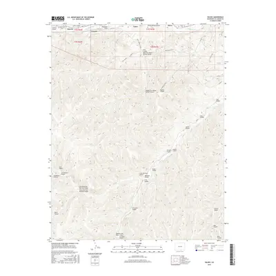
2016 Map of Valdez
USGS Topo · Published 2016About this map
The Purgatoire River carves through the northern reaches of this Colorado landscape, defining the fertile Picketwire Valley where the settlements of Valdez and Segundo are situated. This area reflects a long-standing rural community structure, with local history preserved at the San Juan Cem and Tijeras Cem. The terrain south of the river valley is a complex network of named drainages, including the uniquely titled Widow Woman Canyon and its various forks, alongside Rita Canyon and Madrid Canyon. This topographic arrangement suggests a landscape dominated by ranching and small-scale transit, with routes like Madrid Canyon Rd and Fairview Valley Rd navigating the deep incisions of Martinez Canyon and Sowbelly Canyon. The naming of features such as Opposite Joe Baker Canyon and Penitente Canyon points to a localized, family-based geography typical of the region's historical development.
Find a feature on this map
49 named features on this map. Tap any name to fly to it.
Don’t see what you’re looking for? This feature index may not catch every label — zoom into the map to look around manually.
Map Details
Editions of this 2016 Valdez Map
This is the sole edition of this map. No revisions or reprints were ever made.
Other maps of this area

1891 · Spanish Peaks
USGS Topo · 1:125,000

1893 · Spanish Peaks
USGS Topo · 1:125,000

1895 · Spanish Peaks
USGS Topo · 1:125,000

1897 · Spanish Peaks
USGS Topo · 1:125,000

1900 · Spanish Peaks
USGS Topo · 1:125,000

1915 · Brilliant
USGS Topo · 1:62,500

1951 · Trinidad
USGS Topo · 1:24,000

1951 · Valdez
USGS Topo · 1:24,000

1951 · Madrid
USGS Topo · 1:24,000
1951 · Starkville
USGS Topo · 1:24,000