
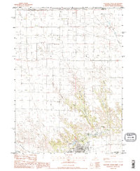
1983 Map of Valentine North
USGS Topo · Published 1984About this map
The Rosebud Indian Reservation spans the northern portion of this landscape, meeting the South Dakota Nebraska border just above the drainage of Beaver Creek. Near the southern edge of the sheet, the town of Valentine serves as a hub for both transportation and conservation, situated along the C & NW railroad and Minnechadua Creek. This area is characterized by the transition from open prairie to the deeply carved Canyon terrain that shelters the Valentine State Fish Hatchery and Fish Hatchery Lake. Local life and genealogy are anchored by rural institutions like the New Harmony Sch and the Richland Harmony Cem to the north, while Frederick Peak provides a prominent landmark overlooking the valley. The presence of the Fort Niobrara National Wildlife Refuge underscores the region's focus on preserving the unique riverine environment of the Niobrara valley.
Find a feature on this map
22 named features on this map. Tap any name to fly to it.
Don’t see what you’re looking for? This feature index may not catch every label — zoom into the map to look around manually.
Map Details
Editions of this 1983 Valentine North Map
2 editions found
Historical Maps of Valentine Through Time
548 maps found

1948 Ashby
Cherry County, NE

1948 Seneca 4
Cherry County, NE

1948 Whitman
Cherry County, NE

1949 Ashby
Cherry County, NE

1949 Big Falls
Cherry County, NE

1949 Long Lake
Cherry County, NE

1949 Purdum
Cherry County, NE

1949 Seneca 4
Cherry County, NE

1949 Steverson Lake
Cherry County, NE

1949 Turpin Lake
Cherry County, NE

1950 Arabia
Cherry County, NE

1950 Doughboy
Cherry County, NE

1950 Hire
Cherry County, NE

1950 Irwin
Cherry County, NE

1950 Kennedy
Cherry County, NE

1950 Powderhorn Valley
Cherry County, NE

1950 Simeon
Cherry County, NE

1950 Sparks
Cherry County, NE

1950 Whitman
Cherry County, NE

1950 Wolf Lake
Cherry County, NE

1951 Big Falls
Cherry County, NE

1951 Bull Lake
Cherry County, NE

1951 Gypsy Valley
Cherry County, NE

1951 Irwin
Cherry County, NE

1951 Long Lake
Cherry County, NE

1951 Merriman 4
Cherry County, NE

1951 Purdum
Cherry County, NE

1951 Steverson Lake
Cherry County, NE

1951 Turpin Lake
Cherry County, NE

1951 Wolf Lake
Cherry County, NE

1952 Doughboy
Cherry County, NE

1952 Eli
Cherry County, NE

1969 Bovee Valley East
Cherry County, NE

1969 Coburn Canyon
Cherry County, NE

1969 Gordon SE
Cherry County, NE

1969 Hog Island
Cherry County, NE

1983 Cornell Dam
Cherry County, NE

1983 Crookston East
Cherry County, NE

1983 Muleshoe Creek
Cherry County, NE

1983 Sparks
Cherry County, NE

1983 Sparks SE
Cherry County, NE

1983 Thatcher
Cherry County, NE
1983 Valentine North
Cherry County, NE

1983 Valentine South
Cherry County, NE

1983 Valentine SW
Cherry County, NE

1985 Arabia
Cherry County, NE

1985 Arabia NW
Cherry County, NE

1985 Arabia SE
Cherry County, NE

1985 Arabia SW
Cherry County, NE

1985 Big Lake
Cherry County, NE

1985 Brownlee Flats
Cherry County, NE

1985 Brush Creek
Cherry County, NE

1985 Chesterfield Flats
Cherry County, NE

1985 Cody East
Cherry County, NE

1985 Cody SE
Cherry County, NE

1985 Cody West
Cherry County, NE

1985 Cooper Canyon
Cherry County, NE

1985 Crookston West
Cherry County, NE

1985 Eli
Cherry County, NE

1985 Eli SE
Cherry County, NE

1985 Eli SW
Cherry County, NE

1985 Ell Lake
Cherry County, NE

1985 Farm Flat
Cherry County, NE

1985 Goose Creek
Cherry County, NE

1985 Harr Valley
Cherry County, NE

1985 Heath Valley
Cherry County, NE

1985 Hudson Lake
Cherry County, NE

1985 Indian Hill
Cherry County, NE

1985 Kennedy
Cherry County, NE

1985 Kennedy NW
Cherry County, NE

1985 Kilgore SE
Cherry County, NE

1985 Long Lake
Cherry County, NE

1985 Long Lake SE
Cherry County, NE

1985 Long Lake SW
Cherry County, NE

1985 Medicine Lake
Cherry County, NE

1985 Mule Lake
Cherry County, NE

1985 Powderhorn Valley
Cherry County, NE

1985 Powderhorn Valley SW
Cherry County, NE

1985 Simeon
Cherry County, NE

1985 Skull Lake
Cherry County, NE

1985 Snake River Falls
Cherry County, NE

1985 Spring Canyon
Cherry County, NE

1985 Spring Lake
Cherry County, NE

1985 Willow Lake
Cherry County, NE

1985 Wilson Valley
Cherry County, NE

1985 Windmill Lake
Cherry County, NE

1986 Duck Lake
Cherry County, NE

1986 Duck Lake NE
Cherry County, NE

1986 Elsmere
Cherry County, NE

1986 Purdum NE
Cherry County, NE

1986 Purdum NW
Cherry County, NE

1987 Allen Valley
Cherry County, NE

1987 Big Falls
Cherry County, NE

1987 Brush Hill
Cherry County, NE

1987 Bull Lake
Cherry County, NE

1987 Carrico Lakes
Cherry County, NE

1987 Coleman Lake
Cherry County, NE

1987 Hire
Cherry County, NE

1987 Hire NE
Cherry County, NE

1987 Lowes Lake
Cherry County, NE

1987 Mayhew Lake
Cherry County, NE

1987 Mullen NE
Cherry County, NE

1987 Mullen NW
Cherry County, NE

1987 Rosebud Valley
Cherry County, NE

1987 Rose Valley
Cherry County, NE

1987 Round Lake
Cherry County, NE

1987 Sevenmile Hill
Cherry County, NE

1987 Square Lake
Cherry County, NE

1987 Steverson Lake
Cherry County, NE

1987 Sunflower Lake
Cherry County, NE

1987 White Willow Lake
Cherry County, NE

1987 Whitman NW
Cherry County, NE

1987 Wolf Lake
Cherry County, NE

1988 Barent Valley
Cherry County, NE

1988 Hill Lake
Cherry County, NE

1989 Bristol Lake
Cherry County, NE

1989 Camp Valley
Cherry County, NE

1989 Card Lake
Cherry County, NE

1989 Mother Lake
Cherry County, NE

1989 Turpin Lake East
Cherry County, NE

1989 Turpin Lake West
Cherry County, NE

1990 Bornemann Lake
Cherry County, NE

1990 Gypsy Valley
Cherry County, NE

1990 Irwin
Cherry County, NE

1990 Irwin SE
Cherry County, NE

1990 Irwin SW
Cherry County, NE

1990 Merriman NE
Cherry County, NE

1990 Merriman SE
Cherry County, NE

1990 Merriman SW
Cherry County, NE

1990 North Valley
Cherry County, NE

1990 Pole Creek Valley
Cherry County, NE

1990 Trumbull Lake
Cherry County, NE

1990 Wild Mare Lake
Cherry County, NE

1990 Wild Mare Lake NW
Cherry County, NE

1990 Wild Mare Lake SE
Cherry County, NE

1990 Wild Mare Lake SW
Cherry County, NE

2011 Allen Valley
Cherry County, NE

2011 Arabia
Cherry County, NE

2011 Arabia NW
Cherry County, NE

2011 Arabia SE
Cherry County, NE

2011 Arabia SW
Cherry County, NE

2011 Barent Valley
Cherry County, NE

2011 Big Falls
Cherry County, NE

2011 Big Lake
Cherry County, NE

2011 Bornemann Lake
Cherry County, NE

2011 Bovee Valley East
Cherry County, NE

2011 Bristol Lake
Cherry County, NE

2011 Brownlee Flats
Cherry County, NE

2011 Brush Creek
Cherry County, NE

2011 Brush Hill
Cherry County, NE

2011 Bull Lake
Cherry County, NE

2011 Camp Valley
Cherry County, NE

2011 Card Lake
Cherry County, NE

2011 Carrico Lakes
Cherry County, NE

2011 Chesterfield Flats
Cherry County, NE

2011 Coburn Canyon
Cherry County, NE

2011 Cody East
Cherry County, NE

2011 Cody SE
Cherry County, NE

2011 Cody West
Cherry County, NE

2011 Coleman Lake
Cherry County, NE

2011 Cooper Canyon
Cherry County, NE

2011 Cornell Dam
Cherry County, NE

2011 Crookston East
Cherry County, NE

2011 Crookston West
Cherry County, NE

2011 Duck Lake
Cherry County, NE

2011 Duck Lake NE
Cherry County, NE

2011 Eli
Cherry County, NE

2011 Eli SE
Cherry County, NE

2011 Eli SW
Cherry County, NE

2011 Ell Lake
Cherry County, NE

2011 Elsmere
Cherry County, NE

2011 Farm Flat
Cherry County, NE

2011 Gordon SE
Cherry County, NE

2011 Gypsy Valley
Cherry County, NE

2011 Harr Valley
Cherry County, NE

2011 Heath Valley
Cherry County, NE

2011 Hill Lake
Cherry County, NE

2011 Hire
Cherry County, NE

2011 Hire NE
Cherry County, NE

2011 Hog Island
Cherry County, NE

2011 Hudson Lake
Cherry County, NE

2011 Indian Hill
Cherry County, NE

2011 Irwin
Cherry County, NE

2011 Irwin SE
Cherry County, NE

2011 Irwin SW
Cherry County, NE

2011 Kennedy
Cherry County, NE

2011 Kennedy NW
Cherry County, NE

2011 Kilgore SE
Cherry County, NE

2011 Long Lake
Cherry County, NE

2011 Long Lake SE
Cherry County, NE

2011 Long Lake SW
Cherry County, NE

2011 Lowes Lake
Cherry County, NE

2011 Mayhew Lake
Cherry County, NE

2011 Medicine Lake
Cherry County, NE

2011 Merriman NE
Cherry County, NE

2011 Merriman SE
Cherry County, NE

2011 Merriman SW
Cherry County, NE

2011 Mother Lake
Cherry County, NE

2011 Mule Lake
Cherry County, NE

2011 Muleshoe Creek
Cherry County, NE

2011 Mullen NE
Cherry County, NE

2011 Mullen NW
Cherry County, NE

2011 North Valley
Cherry County, NE

2011 Pole Creek Valley
Cherry County, NE

2011 Powderhorn Valley
Cherry County, NE

2011 Powderhorn Valley SW
Cherry County, NE

2011 Purdum NE
Cherry County, NE

2011 Purdum NW
Cherry County, NE

2011 Rosebud Valley
Cherry County, NE

2011 Rose Valley
Cherry County, NE

2011 Round Lake
Cherry County, NE

2011 Sevenmile Hill
Cherry County, NE

2011 Simeon
Cherry County, NE

2011 Skull Lake
Cherry County, NE

2011 Snake River Falls
Cherry County, NE

2011 Sparks
Cherry County, NE

2011 Sparks SE
Cherry County, NE

2011 Spring Canyon
Cherry County, NE

2011 Spring Lake
Cherry County, NE

2011 Square Lake
Cherry County, NE

2011 Steverson Lake
Cherry County, NE

2011 Sunflower Lake
Cherry County, NE

2011 Thatcher
Cherry County, NE

2011 Trumbull Lake
Cherry County, NE

2011 Turpin Lake East
Cherry County, NE

2011 Turpin Lake West
Cherry County, NE

2011 Valentine North
Cherry County, NE

2011 Valentine South
Cherry County, NE

2011 Valentine SW
Cherry County, NE

2011 White Willow Lake
Cherry County, NE

2011 Whitman NW
Cherry County, NE

2011 Wild Mare Lake
Cherry County, NE

2011 Wild Mare Lake NW
Cherry County, NE

2011 Wild Mare Lake SE
Cherry County, NE

2011 Wild Mare Lake SW
Cherry County, NE

2011 Willow Lake
Cherry County, NE

2011 Wilson Valley
Cherry County, NE

2011 Windmill Lake
Cherry County, NE

2011 Wolf Lake
Cherry County, NE

2014 Allen Valley
Cherry County, NE

2014 Arabia
Cherry County, NE

2014 Arabia NW
Cherry County, NE

2014 Arabia SE
Cherry County, NE

2014 Arabia SW
Cherry County, NE

2014 Barent Valley
Cherry County, NE

2014 Big Falls
Cherry County, NE

2014 Big Lake
Cherry County, NE

2014 Bornemann Lake
Cherry County, NE

2014 Bovee Valley East
Cherry County, NE

2014 Bristol Lake
Cherry County, NE

2014 Brownlee Flats
Cherry County, NE

2014 Brush Creek
Cherry County, NE

2014 Brush Hill
Cherry County, NE

2014 Bull Lake
Cherry County, NE

2014 Camp Valley
Cherry County, NE

2014 Card Lake
Cherry County, NE

2014 Carrico Lakes
Cherry County, NE

2014 Chesterfield Flats
Cherry County, NE

2014 Coburn Canyon
Cherry County, NE

2014 Cody East
Cherry County, NE

2014 Cody SE
Cherry County, NE

2014 Cody West
Cherry County, NE

2014 Coleman Lake
Cherry County, NE

2014 Cooper Canyon
Cherry County, NE

2014 Cornell Dam
Cherry County, NE

2014 Crookston East
Cherry County, NE

2014 Crookston West
Cherry County, NE

2014 Duck Lake
Cherry County, NE

2014 Duck Lake NE
Cherry County, NE

2014 Eli
Cherry County, NE

2014 Eli SE
Cherry County, NE

2014 Eli SW
Cherry County, NE

2014 Ell Lake
Cherry County, NE

2014 Elsmere
Cherry County, NE

2014 Farm Flat
Cherry County, NE

2014 Gordon SE
Cherry County, NE

2014 Gypsy Valley
Cherry County, NE

2014 Harr Valley
Cherry County, NE

2014 Heath Valley
Cherry County, NE

2014 Hill Lake
Cherry County, NE

2014 Hire
Cherry County, NE

2014 Hire NE
Cherry County, NE

2014 Hog Island
Cherry County, NE

2014 Hudson Lake
Cherry County, NE

2014 Indian Hill
Cherry County, NE

2014 Irwin
Cherry County, NE

2014 Irwin SE
Cherry County, NE

2014 Irwin SW
Cherry County, NE

2014 Kennedy
Cherry County, NE

2014 Kennedy NW
Cherry County, NE

2014 Kilgore SE
Cherry County, NE

2014 Long Lake
Cherry County, NE

2014 Long Lake SE
Cherry County, NE

2014 Long Lake SW
Cherry County, NE

2014 Lowes Lake
Cherry County, NE

2014 Mayhew Lake
Cherry County, NE

2014 Medicine Lake
Cherry County, NE

2014 Merriman NE
Cherry County, NE

2014 Merriman SE
Cherry County, NE

2014 Merriman SW
Cherry County, NE

2014 Mother Lake
Cherry County, NE

2014 Mule Lake
Cherry County, NE

2014 Muleshoe Creek
Cherry County, NE

2014 Mullen NE
Cherry County, NE

2014 Mullen NW
Cherry County, NE

2014 North Valley
Cherry County, NE

2014 Pole Creek Valley
Cherry County, NE

2014 Powderhorn Valley
Cherry County, NE

2014 Powderhorn Valley SW
Cherry County, NE

2014 Purdum NE
Cherry County, NE

2014 Purdum NW
Cherry County, NE

2014 Rosebud Valley
Cherry County, NE

2014 Rose Valley
Cherry County, NE

2014 Round Lake
Cherry County, NE

2014 Sevenmile Hill
Cherry County, NE

2014 Simeon
Cherry County, NE

2014 Skull Lake
Cherry County, NE

2014 Snake River Falls
Cherry County, NE

2014 Sparks
Cherry County, NE

2014 Sparks SE
Cherry County, NE

2014 Spring Canyon
Cherry County, NE

2014 Spring Lake
Cherry County, NE

2014 Square Lake
Cherry County, NE

2014 Steverson Lake
Cherry County, NE

2014 Sunflower Lake
Cherry County, NE

2014 Thatcher
Cherry County, NE

2014 Trumbull Lake
Cherry County, NE

2014 Turpin Lake East
Cherry County, NE

2014 Turpin Lake West
Cherry County, NE

2014 Valentine North
Cherry County, NE

2014 Valentine South
Cherry County, NE

2014 Valentine SW
Cherry County, NE

2014 White Willow Lake
Cherry County, NE

2014 Whitman NW
Cherry County, NE

2014 Wild Mare Lake
Cherry County, NE

2014 Wild Mare Lake NW
Cherry County, NE

2014 Wild Mare Lake SE
Cherry County, NE

2014 Wild Mare Lake SW
Cherry County, NE

2014 Willow Lake
Cherry County, NE

2014 Wilson Valley
Cherry County, NE

2014 Windmill Lake
Cherry County, NE

2014 Wolf Lake
Cherry County, NE

2017 Allen Valley
Cherry County, NE

2017 Arabia
Cherry County, NE

2017 Arabia NW
Cherry County, NE

2017 Arabia SE
Cherry County, NE

2017 Arabia SW
Cherry County, NE

2017 Barent Valley
Cherry County, NE

2017 Big Falls
Cherry County, NE

2017 Big Lake
Cherry County, NE

2017 Bornemann Lake
Cherry County, NE

2017 Bovee Valley East
Cherry County, NE

2017 Bristol Lake
Cherry County, NE

2017 Brownlee Flats
Cherry County, NE

2017 Brush Creek
Cherry County, NE

2017 Brush Hill
Cherry County, NE

2017 Bull Lake
Cherry County, NE

2017 Camp Valley
Cherry County, NE

2017 Card Lake
Cherry County, NE

2017 Carrico Lakes
Cherry County, NE

2017 Chesterfield Flats
Cherry County, NE

2017 Coburn Canyon
Cherry County, NE

2017 Cody East
Cherry County, NE

2017 Cody SE
Cherry County, NE

2017 Cody West
Cherry County, NE

2017 Coleman Lake
Cherry County, NE

2017 Cooper Canyon
Cherry County, NE

2017 Cornell Dam
Cherry County, NE

2017 Crookston East
Cherry County, NE

2017 Crookston West
Cherry County, NE

2017 Duck Lake
Cherry County, NE

2017 Duck Lake NE
Cherry County, NE

2017 Eli
Cherry County, NE

2017 Eli SE
Cherry County, NE

2017 Eli SW
Cherry County, NE

2017 Ell Lake
Cherry County, NE

2017 Elsmere
Cherry County, NE

2017 Farm Flat
Cherry County, NE

2017 Gordon SE
Cherry County, NE

2017 Gypsy Valley
Cherry County, NE

2017 Harr Valley
Cherry County, NE

2017 Heath Valley
Cherry County, NE

2017 Hill Lake
Cherry County, NE

2017 Hire
Cherry County, NE

2017 Hire NE
Cherry County, NE

2017 Hog Island
Cherry County, NE

2017 Hudson Lake
Cherry County, NE

2017 Indian Hill
Cherry County, NE

2017 Irwin
Cherry County, NE

2017 Irwin SE
Cherry County, NE

2017 Irwin SW
Cherry County, NE

2017 Kennedy
Cherry County, NE

2017 Kennedy NW
Cherry County, NE

2017 Kilgore SE
Cherry County, NE

2017 Long Lake
Cherry County, NE

2017 Long Lake SE
Cherry County, NE

2017 Long Lake SW
Cherry County, NE

2017 Lowes Lake
Cherry County, NE

2017 Mayhew Lake
Cherry County, NE

2017 Medicine Lake
Cherry County, NE

2017 Merriman NE
Cherry County, NE

2017 Merriman SE
Cherry County, NE

2017 Merriman SW
Cherry County, NE

2017 Mother Lake
Cherry County, NE

2017 Mule Lake
Cherry County, NE

2017 Muleshoe Creek
Cherry County, NE

2017 Mullen NE
Cherry County, NE

2017 Mullen NW
Cherry County, NE

2017 North Valley
Cherry County, NE

2017 Pole Creek Valley
Cherry County, NE

2017 Powderhorn Valley
Cherry County, NE

2017 Powderhorn Valley SW
Cherry County, NE

2017 Purdum NE
Cherry County, NE

2017 Purdum NW
Cherry County, NE

2017 Rosebud Valley
Cherry County, NE

2017 Rose Valley
Cherry County, NE

2017 Round Lake
Cherry County, NE

2017 Sevenmile Hill
Cherry County, NE

2017 Simeon
Cherry County, NE

2017 Skull Lake
Cherry County, NE

2017 Snake River Falls
Cherry County, NE

2017 Sparks
Cherry County, NE

2017 Sparks SE
Cherry County, NE

2017 Spring Canyon
Cherry County, NE

2017 Spring Lake
Cherry County, NE

2017 Square Lake
Cherry County, NE

2017 Steverson Lake
Cherry County, NE

2017 Sunflower Lake
Cherry County, NE

2017 Thatcher
Cherry County, NE

2017 Trumbull Lake
Cherry County, NE

2017 Turpin Lake East
Cherry County, NE

2017 Turpin Lake West
Cherry County, NE

2017 Valentine North
Cherry County, NE

2017 Valentine South
Cherry County, NE

2017 Valentine SW
Cherry County, NE

2017 White Willow Lake
Cherry County, NE

2017 Whitman NW
Cherry County, NE

2017 Wild Mare Lake
Cherry County, NE

2017 Wild Mare Lake NW
Cherry County, NE

2017 Wild Mare Lake SE
Cherry County, NE

2017 Wild Mare Lake SW
Cherry County, NE

2017 Willow Lake
Cherry County, NE

2017 Wilson Valley
Cherry County, NE

2017 Windmill Lake
Cherry County, NE

2017 Wolf Lake
Cherry County, NE

2021 Allen Valley
Cherry County, NE

2021 Arabia
Cherry County, NE

2021 Arabia NW
Cherry County, NE

2021 Arabia SE
Cherry County, NE

2021 Arabia SW
Cherry County, NE

2021 Barent Valley
Cherry County, NE

2021 Big Falls
Cherry County, NE

2021 Big Lake
Cherry County, NE

2021 Bornemann Lake
Cherry County, NE

2021 Bovee Valley East
Cherry County, NE

2021 Bristol Lake
Cherry County, NE

2021 Brownlee Flats
Cherry County, NE

2021 Brush Creek
Cherry County, NE

2021 Brush Hill
Cherry County, NE

2021 Bull Lake
Cherry County, NE

2021 Camp Valley
Cherry County, NE

2021 Card Lake
Cherry County, NE

2021 Carrico Lakes
Cherry County, NE

2021 Chesterfield Flats
Cherry County, NE

2021 Coburn Canyon
Cherry County, NE

2021 Cody East
Cherry County, NE

2021 Cody SE
Cherry County, NE

2021 Cody West
Cherry County, NE

2021 Coleman Lake
Cherry County, NE

2021 Cooper Canyon
Cherry County, NE

2021 Cornell Dam
Cherry County, NE

2021 Crookston East
Cherry County, NE

2021 Crookston West
Cherry County, NE

2021 Duck Lake
Cherry County, NE

2021 Duck Lake NE
Cherry County, NE

2021 Eli
Cherry County, NE

2021 Eli SE
Cherry County, NE

2021 Eli SW
Cherry County, NE

2021 Ell Lake
Cherry County, NE

2021 Elsmere
Cherry County, NE

2021 Farm Flat
Cherry County, NE

2021 Gordon SE
Cherry County, NE

2021 Gypsy Valley
Cherry County, NE

2021 Harr Valley
Cherry County, NE

2021 Heath Valley
Cherry County, NE

2021 Hill Lake
Cherry County, NE

2021 Hire
Cherry County, NE

2021 Hire NE
Cherry County, NE

2021 Hog Island
Cherry County, NE

2021 Hudson Lake
Cherry County, NE

2021 Indian Hill
Cherry County, NE

2021 Irwin
Cherry County, NE

2021 Irwin SE
Cherry County, NE

2021 Irwin SW
Cherry County, NE

2021 Kennedy
Cherry County, NE

2021 Kennedy NW
Cherry County, NE

2021 Kilgore SE
Cherry County, NE

2021 Long Lake
Cherry County, NE

2021 Long Lake SE
Cherry County, NE

2021 Long Lake SW
Cherry County, NE

2021 Lowes Lake
Cherry County, NE

2021 Mayhew Lake
Cherry County, NE

2021 Medicine Lake
Cherry County, NE

2021 Merriman NE
Cherry County, NE

2021 Merriman SE
Cherry County, NE

2021 Merriman SW
Cherry County, NE

2021 Mother Lake
Cherry County, NE

2021 Mule Lake
Cherry County, NE

2021 Muleshoe Creek
Cherry County, NE

2021 Mullen NE
Cherry County, NE

2021 Mullen NW
Cherry County, NE

2021 North Valley
Cherry County, NE

2021 Pole Creek Valley
Cherry County, NE

2021 Powderhorn Valley
Cherry County, NE

2021 Powderhorn Valley SW
Cherry County, NE

2021 Purdum NE
Cherry County, NE

2021 Purdum NW
Cherry County, NE

2021 Rosebud Valley
Cherry County, NE

2021 Rose Valley
Cherry County, NE

2021 Round Lake
Cherry County, NE

2021 Sevenmile Hill
Cherry County, NE

2021 Simeon
Cherry County, NE

2021 Skull Lake
Cherry County, NE

2021 Snake River Falls
Cherry County, NE

2021 Sparks
Cherry County, NE

2021 Sparks SE
Cherry County, NE

2021 Spring Canyon
Cherry County, NE

2021 Spring Lake
Cherry County, NE

2021 Square Lake
Cherry County, NE

2021 Steverson Lake
Cherry County, NE

2021 Sunflower Lake
Cherry County, NE

2021 Thatcher
Cherry County, NE

2021 Trumbull Lake
Cherry County, NE

2021 Turpin Lake East
Cherry County, NE

2021 Turpin Lake West
Cherry County, NE

2021 Valentine North
Cherry County, NE

2021 Valentine South
Cherry County, NE

2021 Valentine SW
Cherry County, NE

2021 White Willow Lake
Cherry County, NE

2021 Whitman NW
Cherry County, NE

2021 Wild Mare Lake
Cherry County, NE

2021 Wild Mare Lake NW
Cherry County, NE

2021 Wild Mare Lake SE
Cherry County, NE

2021 Wild Mare Lake SW
Cherry County, NE

2021 Willow Lake
Cherry County, NE

2021 Wilson Valley
Cherry County, NE

2021 Windmill Lake
Cherry County, NE

2021 Wolf Lake
Cherry County, NE