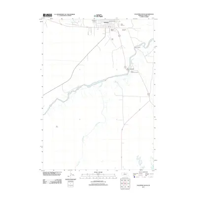
2011 Map of Valentine South
USGS Topo · Published 2011About this map
The southern outskirts of Valentine and the winding course of the Niobrara River dominate this 2011 survey of Nebraska's Sandhills region. The map captures the transition from the organized grid of the town, featuring the Valentine Post Office and Cherry County Fairgrounds, into the expansive ranching landscape represented by the Heth Ranch. Two significant crossings, the Borman Bridge and the Bryan Bridge, mark the river’s path as it flows eastward, joined from the south by the meandering Schlagel Creek. Local history is anchored by the Minnechaduza Cemetery and Mount Hope Cemetery, while the presence of Miller Field and the Valentine Motel and RV Park indicates the area's role as a regional hub and gateway for visitors exploring the river valley. The infrastructure is defined by a network of rural routes such as Chaduza Rd and Road 220 that connect these remote ranch lands and scenic landmarks.
Find a feature on this map
22 named features on this map. Tap any name to fly to it.
Don’t see what you’re looking for? This feature index may not catch every label — zoom into the map to look around manually.
Map Details
Editions of this 2011 Valentine South Map
This is the sole edition of this map. No revisions or reprints were ever made.
Other maps of this area

1950 · Sparks
USGS Topo · 1:62,500

1950 · Simeon
USGS Topo · 1:62,500

1950 · Arabia
USGS Topo · 1:62,500

1950 · Valentine
USGS Topo · 1:62,500

1957 · Valentine
USGS Topo · 1:250,000

1959 · Valentine
USGS Topo · 1:250,000
1983 · Crookston East
USGS Topo · 1:24,000

1983 · Valentine SW
USGS Topo · 1:24,000
1983 · Valentine North
USGS Topo · 1:24,000

1983 · Valentine South
USGS Topo · 1:24,000