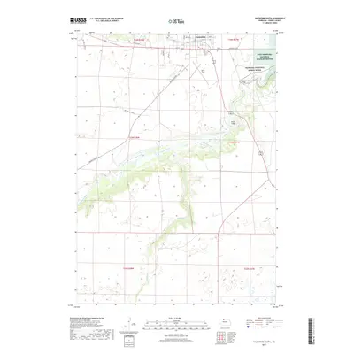
2017 Map of Valentine South
USGS Topo · Published 2017About this map
Valentine stands at the northern edge of this Cherry County landscape, serving as a gateway to the federally protected lands of the Fort Niobrara National Wildlife Refuge. The Niobrara River carves a distinct corridor through the center of the quadrangle, protected as the Niobrara National Scenic River. This waterway is crossed by notable infrastructure including Bryan Bridge and Borman Bridge, while the surrounding terrain is marked by the course of Schlagel Cr and the evocative One Trail Cowpath. Local history is anchored by the Mount Hope Cem and Minnechaduza Cem, alongside the aviation history of Miller Field. The map illustrates the transition from the structured street grid of Valentine, with routes like Chaduza Rd, to the more expansive, rural sections defined by the Merritt Dam Rd and various township lines.
Find a feature on this map
31 named features on this map. Tap any name to fly to it.
Don’t see what you’re looking for? This feature index may not catch every label — zoom into the map to look around manually.
Map Details
Editions of this 2017 Valentine South Map
This is the sole edition of this map. No revisions or reprints were ever made.
Other maps of this area

1950 · Sparks
USGS Topo · 1:62,500

1950 · Simeon
USGS Topo · 1:62,500

1950 · Arabia
USGS Topo · 1:62,500

1950 · Valentine
USGS Topo · 1:62,500

1957 · Valentine
USGS Topo · 1:250,000

1959 · Valentine
USGS Topo · 1:250,000
1983 · Crookston East
USGS Topo · 1:24,000

1983 · Valentine SW
USGS Topo · 1:24,000
1983 · Valentine North
USGS Topo · 1:24,000

1983 · Valentine South
USGS Topo · 1:24,000