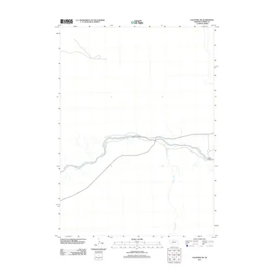
2011 Map of Valentine SW
USGS Topo · Published 2011About this map
The Niobrara River carves a significant east-west path through this portion of Cherry County, defining the local hydrology and travel patterns. This 2011 survey captures the river's winding course as it meets the northern flow of Gordon Creek, a prominent tributary in this Nebraska landscape. The map highlights the sparse but critical infrastructure of the region, specifically noting the location of the Darr Bridge, which facilitates movement across these waters. The surrounding terrain reflects a classic Sandhills river valley, where water sources like these dictated the placement of early ranching routes and local crossings.
Find a feature on this map
3 named features on this map. Tap any name to fly to it.
Don’t see what you’re looking for? This feature index may not catch every label — zoom into the map to look around manually.
Map Details
Editions of this 2011 Valentine SW Map
This is the sole edition of this map. No revisions or reprints were ever made.
Other maps of this area

1950 · Simeon
USGS Topo · 1:62,500

1950 · Kennedy
USGS Topo · 1:62,500

1950 · Kilgore
USGS Topo · 1:62,500

1950 · Valentine
USGS Topo · 1:62,500

1957 · Valentine
USGS Topo · 1:250,000

1959 · Valentine
USGS Topo · 1:250,000
1983 · Crookston East
USGS Topo · 1:24,000

1983 · Valentine SW
USGS Topo · 1:24,000
1983 · Valentine North
USGS Topo · 1:24,000

1983 · Valentine South
USGS Topo · 1:24,000