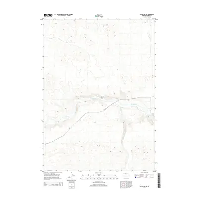
2014 Map of Valentine SW
USGS Topo · Published 2014About this map
The Niobrara River carves a deep east-west canyon through this portion of Cherry County, creating a sharp contrast between the river valley and the high Nebraska sandhills. Two critical crossing points, the Moosman Bridge and Darr Bridge, provide passage over the water in this rural landscape. The waterway is joined from the south by the winding Gordon Cr, which meanders through the hills to reach the main river channel. Transport through this area is primarily served by the Ne-97 highway, which follows the natural contours of the land south of the river before crossing north. This 2014 survey illustrates how geography dictates movement in north-central Nebraska, where infrastructure is concentrated at specific bridge crossings and along established state routes.
Find a feature on this map
5 named features on this map. Tap any name to fly to it.
Don’t see what you’re looking for? This feature index may not catch every label — zoom into the map to look around manually.
Map Details
Editions of this 2014 Valentine SW Map
This is the sole edition of this map. No revisions or reprints were ever made.
Other maps of this area

1950 · Simeon
USGS Topo · 1:62,500

1950 · Kennedy
USGS Topo · 1:62,500

1950 · Kilgore
USGS Topo · 1:62,500

1950 · Valentine
USGS Topo · 1:62,500

1957 · Valentine
USGS Topo · 1:250,000

1959 · Valentine
USGS Topo · 1:250,000
1983 · Crookston East
USGS Topo · 1:24,000

1983 · Valentine SW
USGS Topo · 1:24,000
1983 · Valentine North
USGS Topo · 1:24,000

1983 · Valentine South
USGS Topo · 1:24,000