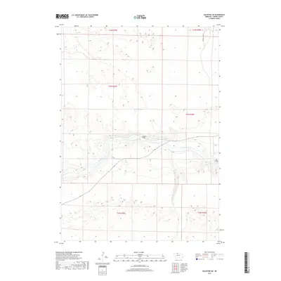
2017 Map of Valentine SW
USGS Topo · Published 2017About this map
The Niobrara River carves through the heart of this Nebraska landscape, defining the topography with its winding channel and steep valley walls. In this rural expanse of Cherry County, the river remains the primary geographic anchor, crossed by small-scale infrastructure like the Moosman Bridge and Darr Bridge. These crossings facilitate movement across a terrain otherwise dominated by the vast drainage system of Gordon Cr and the undulating sandhills north and south of the river valley. The presence of the One Trail Cowpath in the northeastern section suggests the long-standing agricultural and ranching traditions of the region, where movement was often dictated by the contours of the land and the location of water. This 2017 survey details the section lines and township boundaries that organize this largely undeveloped part of the Great Plains.
Find a feature on this map
11 named features on this map. Tap any name to fly to it.
Don’t see what you’re looking for? This feature index may not catch every label — zoom into the map to look around manually.
Map Details
Editions of this 2017 Valentine SW Map
This is the sole edition of this map. No revisions or reprints were ever made.
Other maps of this area

1950 · Simeon
USGS Topo · 1:62,500

1950 · Kennedy
USGS Topo · 1:62,500

1950 · Kilgore
USGS Topo · 1:62,500

1950 · Valentine
USGS Topo · 1:62,500

1957 · Valentine
USGS Topo · 1:250,000

1959 · Valentine
USGS Topo · 1:250,000
1983 · Crookston East
USGS Topo · 1:24,000

1983 · Valentine SW
USGS Topo · 1:24,000
1983 · Valentine North
USGS Topo · 1:24,000

1983 · Valentine South
USGS Topo · 1:24,000