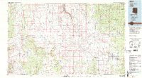
1983 Map of Valle
USGS Topo · Published 1983About this map
Coconino Plateau defines this high-altitude landscape, characterized by a complex network of seasonal drainages and ephemeral water bodies like Red Lake and Tule Lake. The mapping reflects the infrastructure of the early 1980s, centered on the settlement of Valle at the junction of key transportation corridors. The arrival of the Atchison Topeka and Santa Fe railroad line remains a primary landmark, cutting through the vast plateau toward the north. To the northeast, the development of Tusayan and the Grand Canyon Airport indicates the region's role as a gateway to the neighboring Grand Canyon National Park. Remote camps and outposts such as Tin House and Rose-Well Camp are scattered across the terrain, while the deep incision of Cataract Canyon marks the western reach of the sheet, providing a stark contrast to the surrounding tablelands.
Find a feature on this map
38 named features on this map. Tap any name to fly to it.
Don’t see what you’re looking for? This feature index may not catch every label — zoom into the map to look around manually.
Map Details
Editions of this 1983 Valle Map
3 editions found
Other maps of this area

1886 · Diamond Creek
USGS Topo · 1:250,000

1886 · San Francisco Mtns
USGS Topo · 1:250,000

1886 · Mt. Trumbull
USGS Topo · 1:250,000

1886 · Chino
USGS Topo · 1:250,000

1886 · Echo Cliffs
USGS Topo · 1:250,000

1886 · Kaibab
USGS Topo · 1:250,000

1891 · San Francisco Mtns
USGS Topo · 1:250,000

1891 · Chino
USGS Topo · 1:250,000

1891 · Echo Cliffs
USGS Topo · 1:250,000

1892 · Diamond Creek
USGS Topo · 1:250,000