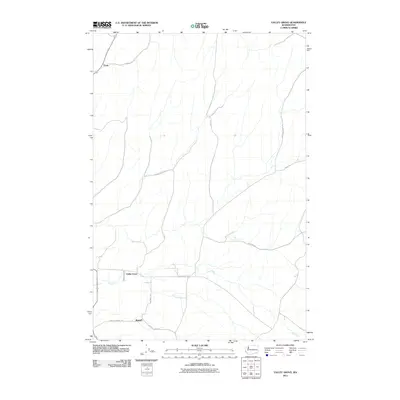
2011 Map of Valley Grove
USGS Topo · Published 2011About this map
The agricultural landscape of Walla Walla County is defined by the winding course of Dry Creek and a network of rural routes connecting small localized settlements. Valley Grove serves as a central point in this transition zone, where the flat valley floor begins to interact with the rising topography to the north. Further south, Russell sits near the namesake Russell Siding Rd, reflecting the region's historical reliance on transportation corridors for moving local crops. To the northwest, the small settlement of Ennis is positioned along the approach to the northern hills.
Find a feature on this map
16 named features on this map. Tap any name to fly to it.
Don’t see what you’re looking for? This feature index may not catch every label — zoom into the map to look around manually.
Map Details
Editions of this 2011 Valley Grove Map
This is the sole edition of this map. No revisions or reprints were ever made.
Other maps of this area

1919 · Walla Walla
USGS Topo · 1:125,000

1921 · Walla Walla
USGS Topo · 1:125,000

1953 · Walla Walla
USGS Topo · 1:250,000

1958 · Walla Walla
USGS Topo · 1:250,000

1966 · Dixie
USGS Topo · 1:24,000
1966 · Buroker
USGS Topo · 1:24,000

1966 · Hadley
USGS Topo · 1:24,000

1966 · Valley Grove
USGS Topo · 1:24,000
1966 · Walla Walla
USGS Topo · 1:24,000
1966 · College Place
USGS Topo · 1:24,000