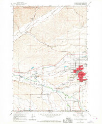
1966 Map of College Place
USGS Topo · Published 1968About this map
College Place and the surrounding agricultural valleys of southeastern Washington are captured in detail during the mid-1960s. The landscape is defined by the convergence of the Walla Walla River and Mill Creek, where extensive irrigation networks like the Ditch and Yellowhawk Creek support the region's productive farmlands. Cultural and educational institutions are central to the community, notably Walla Walla College and the Walla Walla Valley Academy. The map highlights the intersection of transportation and history, showing the Union Pacific and Northern Pacific rail lines serving grain elevators at Sudbury and Whitman.
Find a feature on this map
54 named features on this map. Tap any name to fly to it.
Don’t see what you’re looking for? This feature index may not catch every label — zoom into the map to look around manually.
Map Details
Editions of this 1966 College Place Map
2 editions found
Other maps of this area

1915 · Wallulah
USGS Topo · 1:96,000

1918 · Wallula
USGS Topo · 1:125,000

1919 · Walla Walla
USGS Topo · 1:125,000

1921 · Walla Walla
USGS Topo · 1:125,000

1935 · Pendleton
USGS Topo · 1:125,000

1953 · Pendleton
USGS Topo · 1:250,000

1953 · Walla Walla
USGS Topo · 1:250,000

1956 · Pendleton
USGS Topo · 1:250,000

1958 · Walla Walla
USGS Topo · 1:250,000

1964 · Milton-Freewater
USGS Topo · 1:24,000