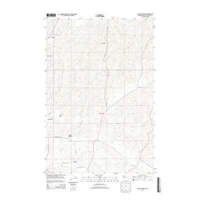
2014 Map of Valley Grove
USGS Topo · Published 2014About this map
Valley Grove and the small agricultural cluster at Russell anchor this portion of Walla Walla County, characterized by a complex network of rolling upland drainages. The seasonal flow of Dry Cr carves through the central landscape, dictating the placement of early travel corridors like Valley Grove Rd and McInroe Rd. Further north, the tiny settlements of Spring Valley and Ennis are linked by rural routes that follow the natural topography, such as Spring Valley Rd and Hart Rd. The prevalence of family-named thoroughfares like Bergevin Springs Rd and Russell Siding Rd points to the area's deep-rooted ranching and farming history. This 2014 survey captures the persistence of these small crossroads and the enduring rural infrastructure of the region.
Find a feature on this map
19 named features on this map. Tap any name to fly to it.
Don’t see what you’re looking for? This feature index may not catch every label — zoom into the map to look around manually.
Map Details
Editions of this 2014 Valley Grove Map
This is the sole edition of this map. No revisions or reprints were ever made.
Other maps of this area

1919 · Walla Walla
USGS Topo · 1:125,000

1921 · Walla Walla
USGS Topo · 1:125,000

1953 · Walla Walla
USGS Topo · 1:250,000

1958 · Walla Walla
USGS Topo · 1:250,000

1966 · Dixie
USGS Topo · 1:24,000
1966 · Buroker
USGS Topo · 1:24,000

1966 · Hadley
USGS Topo · 1:24,000

1966 · Valley Grove
USGS Topo · 1:24,000
1966 · Walla Walla
USGS Topo · 1:24,000
1966 · College Place
USGS Topo · 1:24,000